TRAFFIC INVENTORY COLLECTION, ROAD DAMAGE, CLEARANCE ASSESSMENT, CORRIDOR MAPPING
Rail, Roads & Urban Infrastructure

Whether it is mobile laser scanning from various platforms like cars, railcars, boats or even bicycles, or rapid static laser scanning on a tripod, RIEGL provides the right laser scanner or complete laser scanning system for the job. Kinematic laser scanning can be carried out without obstruction of the traffic, or track closures. For comprehensive coverage of critical infrastructure like bridges the long range measuring capabilities of the RIEGL systems make a difference.

Keep an eye on critical infrastructure

Over the entire lifecycle of infrastructure assets, laser scanning contributes valuable data from planning to operation and maintenance and final decommissioning of the assets. In the planning phase LiDAR data provides a fundamental reference dataset of the terrain any existing infrastructure. The data is used for proper slope design and pre-calculation of required earthworks. During the construction phase repeated laser scanning provides a thorough documentation of moved masses, fill grades, excavation volumes. A regular repetitive LiDAR acquisition can also be used for as-built to design comparison to prove compliance or reveal discrepancies to the design. In the operational phase of the infrastructure asset, laser scanning provides critical information for safe operations like clearance, vegetation encroachment, or degradation by wear like crack detection or rutting of street surfaces. 

In that context RIEGL's mobile mapping laser scanning systems add an additional level of safety by not only providing 3D LiDAR data, but also high quality camera imagery.

The kinematic data acquisitions can be performed rapidly, often from moving vehicles, drones or helicopters, which significantly reduces the time required for data collection compared to traditional surveying methods. As it is a non-contact surveying method, meaning it does not interfere with the operation of the infrastructure being scanned. This is particularly beneficial for busy roads and active rail lines where minimal disruption is crucial.

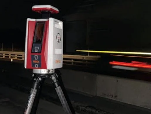
Static long range laser scanning of infrastructure provides highly accurate measurements, which are crucial for detecting structural issues or deformations in infrastructure. This precision helps in identifying potential problems before they become serious. Regular LiDAR scans can be used to monitor changes and deformations over time, providing valuable data for predictive maintenance and long-term infrastructure management.

Generally LiDAR can be used in various environments and conditions, including night-time and low-visibility scenarios, making it a versatile tool for infrastructure surveying and monitoring.

RIEGL's kinematic and static laser scanning systems are an invaluable tool for the maintenance, planning, and management of rail, road infrastructure, and bridges, ensuring they remain safe, functional, and efficient.

RAIL, ROADS & URBAN INFRASTRUCTURE
Products

TLS
RIEGL VZ-600i

RIEGL VZ-600i

Extremely Versatile High Performance 3D Terrestrial Laser Scanner Details
TLS
<em>RIEGL</em> VZ-400i - Terrestrial Laser Scanning

RIEGL VZ-400i

High Performance 3D Laser Scanner Details
MLS
<em>RIEGL</em> VMY-1 for Mobile Laser Scanning

RIEGL VMY-1

Extremely Compact Single Scanner Mobile Mapping System Details
MLS
<em>RIEGL</em> VMY-2 for Mobile Laser Scanning

RIEGL VMY-2

Compact Dual Scanner Mobile Mapping System Details
MLS
<em>RIEGL</em> VMQ-1HA for Mobile Laser Scanning

RIEGL VMQ-1HA

High Speed, Single Scanner Mobile Mapping System Details
MLS
<em>RIEGL</em> VMX-2HA for Mobile Laser Scanning

RIEGL VMX-2HA

High Speed, High Performance Dual Scanner Mobile Mapping System Details
MLS
<em>RIEGL</em> VMX-RAIL for Mobile Laser Scanning

RIEGL VMX-RAIL

Triple Scanner Mobile Mapping System Specifically Designed for Rail Application Details
MLS, TLS
<em>RIEGL</em> VMR

RIEGL VMR

Robotic Rail Laser Scanning System Details
MLS
<em>RIEGL</em> miniVUX-HA for Mobile Laser Scanning

RIEGL miniVUX-HA

LiDAR Sensor for KINEMATIC Laser Scanning Details
MLS
<em>RIEGL</em> VUX-1HA-22 for Mobile Laser Scanning

RIEGL VUX-1HA22

High-Performance LiDAR Sensor for KINEMATIC Laser Scanning Details
ALS
<em>RIEGL</em> VQ-1560 III S - Airborne Laser Scanning

RIEGL VQ-1560 III-S NEW

Dual Channel Waveform Processing Airborne LiDAR Scanning System for High Point Density Mapping and Ultra-Wide Area Mapping Details
ALS
<em>RIEGL</em> VQ-1460 - Airborne Laser Scanning

RIEGL VQ-1460

Waveform Processing Airborne LiDAR Scanning System for High Point Density Mapping and Ultra-Wide Area Mapping Details
ALS
<em>RIEGL</em> VQ-1260 - Airborne Laser Scanning

RIEGL VQ-1260

Waveform Processing Airborne LiDAR Scanning System for High Point Density Mapping and Ultra-Wide Area Mapping Details
ALS
<em>RIEGL</em> VQ-780 II-S - Airborne Laser Scanning

RIEGL VQ-780 II-S

Waveform Processing Airborne Laser Scanner for Wide Area Mapping and High Productivity Details
ALS
<em>RIEGL</em> VQ-680 - Airborne Laser Scanning

RIEGL VQ-680 NEW

High-End Online Waveform Processing Airborne LiDAR Scanner with Nadir/Forward/Backward-Scanning Details
ALS
<em>RIEGL</em> VQ-580 II-S - Airborne Laser Scanning

RIEGL VQ-580 II-S

Waveform Processing Airborne Laser Scanning System with Increased Range Capacity Details
ALS
<em>RIEGL</em> VQ-480_II - Airborne Laser Scanning

RIEGL VQ-480 II

Waveform Processing Airborne Laser Scanning System Details
ALS
<em>RIEGL</em> VUX-1LR-22 - Airborne Laser Scanning

RIEGL VUX-1LR22

Lightweight Airborne Laser Scanner with Online Waveform Processing Details
ULS, ALS
<em>RIEGL</em> VUX-240-24 - UAV Based Laser Scanning

RIEGL VUX-24024

Versatile Airborne Laser Scanner with Online Waveform Processing Details
ALS
<em>RIEGL</em> VP-1 for Airborne Laser Scanning

RIEGL VP-1

Helicopter Pod for Airborne Laser Scanning (ALS) Details
ALS

RIEGL VPX-1

Helicopter Pod for Airborne Laser Scanning (ALS) Details
ALS

RIEGL VQX-2 Helicopter Pod

Helicopter Pod for Airborne Laser Scanning (ALS) Details
ALS
<em>RIEGL</em> VQX-1 Wing Pod for Airborne Laser Scanning

RIEGL VQX-1 Wing Pod

Fully Integrated Airborne Laser Scanning System Details
ULS
<em>RIEGL</em> VUX-180-24 for UAV-based Laser Scanning

RIEGL VUX-18024 NEW

UAV LiDAR Sensor for High-Speed Corridor Mapping Details
ULS
<em>RIEGL</em> VUX-160-23 for UAV-based Laser Scanning

RIEGL VUX-16023

"NFB" (Nadir/Forward/Backward) Scanning UAV LiDAR Sensor Details
ULS
<em>RIEGL</em> VUX-120-23 for UAV-based Laser Scanning

RIEGL VUX-12023

"NFB" (Nadir/Forward/Backward) Scanning UAV LiDAR Sensor Details
ULS
<em>RIEGL</em> VUX-100-25 for UAV-based Laser Scanning

RIEGL VUX-10025 NEW

UAV LiDAR Sensor for Wide Area Coverage with Extra Large Field of View Details
ULS
<em>RIEGL</em> VUX-1UAV-22 for UAV-based Laser Scanning

RIEGL VUX-1UAV22

Lightweight UAV Laser Scanner with Online Waveform Processing Details

You are not sure which one to choose. Find the right product for your application with our

Product Finder

CONTACT
Get in touch.

All you need to know about our products or any other RIEGL solution - our Sales Team is taking your questions: 

info@riegl.asia 

For technical support please click here.