

All RIEGL terrestrial laser scanners are rugged and fully portable instruments, tested under strict conditions for a reliable performance even under highly demanding environmental conditions.
For convenient use of terrestrial scanners RIEGL provides RiSCAN PRO, RIEGL's Operating & Processing Software for 3D Laser Scanners. Additionally, special software packages and tools are offered, e.g. RiPANO to explore your project and to extract plots in your browser.
Measurement and image data captured with RIEGL 3D laser scanners can be visualized with BENACO's services in browser-based, immersive and flexible 3D tours.
To enable the connection of a RIEGL 3D laser scanner to a robot with a ROS (Robot Operating System), RIEGL offers the ROS2 RIEGL VZ Package, an open-source robotics middleware suite providing nodes, topics and services. It provides a ROS interface for scan data acquisition and the scan position registration feature of the VZ-i laser scanners.
To enhance the capability of RIEGL's software suite, RIEGL's Deep Learning Suite of artificial intelligence methods is now available to support users with special tools in processing of terrestrial and kinematic data. You will find a first overview here.
Information on the RIEGL software packages for terrestrial laser scanning can be found here.
TERRESTRIAL SCANNING
Products

RIEGL VZ-600i

RIEGL VZ-400i

RIEGL VZ-1200i NEW

RIEGL VZ-2000i

RIEGL VZ-4000i25

RIEGL VZ-6000i26
Not sure which product is right for you? Find the right product for your application with our
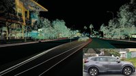
TERRESTRIAL SCANNING
Case Studies


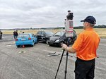
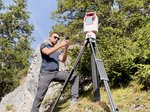
TERRESTRIAL SCANNING
Gallery


TERRESTRIAL SCANNING
News & Insights


CONTACT
Get in touch.
Our team is happy to answer any questions you may have about RIEGL products and solutions. For technical support or general inquiries, please use the contact details below.
Technical Support:
info@riegl.asia
General Questions:
info@riegl.asia
+852 21808374
Looking for more information?
Send us your request using the product inquiry form.