
TERRESTRIAL SOFTWARE
RiSOLVE
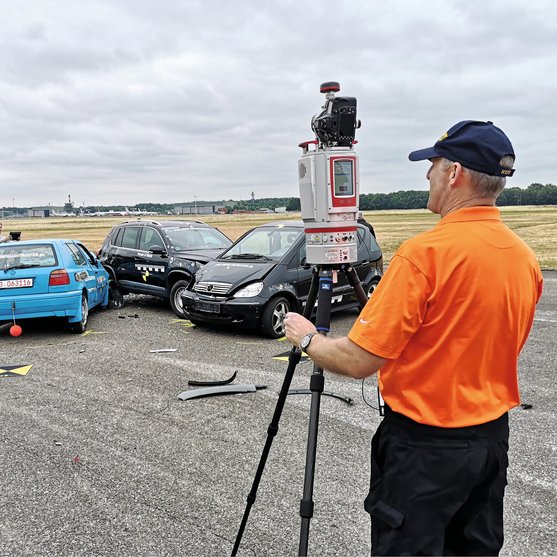
RiSOLVE is RIEGL's software for documentation of crash and crime scenes for analysis and investigation.
Accurate Scene Reconstruction – Fast and Automated
Combined with the one-touch workflow of the RIEGL V-Line Terrestrial Laser Scanners, RiSOLVE enables fully automatic registration and colorization of scan data. This stream-lined process is the fastest solution to acquire, register, and colorize outdoor 3D scan data. With additional tools for filtering, scene animation and measurements, RiSOLVE enables rapid turnaroud of critical information.
RiSOLVE takes the complexity out of the registration process by utilizing positioning information provided by sensors integrated into RIEGL VZ-Line scanners. Combining position estimation utilizing this onboard sensor data along with a new algorithm for aligning scans without reflectors or precise positioning enables a fine adjustment of all scans to produce seamless fully registered point clouds.
Main Features
- RiSOLVE with 64-bit architecture, GeoSys Manager supported
- fully automatic registration
- fastest true-color scanning workflow
- calibration, registration, and filtering tools
- 2D measureable PDF plots
- simple data export
Datasheets & Further Information
Members Area
Looking for our software download? The download is exclusively accessible to RIEGL customers.
CONTACT
Get in touch.
Our team is happy to answer any questions you may have about RIEGL products and solutions. For technical support or general inquiries, please use the contact details below.
Technical Support:
info@riegl.asia
General Questions:
info@riegl.asia
+852 21808374
Looking for more information?
Send us your request using the product inquiry form.