NEWS, CASE STUDY
Where Tradition Meets Technology: RIEGL LiDAR Captures Bhutan’s Gangtey Monastery
Bhutan, the Himalayan kingdom long admired for its spiritual depth and untouched natural beauty, is home to cultural treasures found nowhere else on earth. To ensure the preservation of one such site — the revered Gangtey (Gangteng) Monastery overlooking the Phobjikha Valley — RIEGL’s VZ‑600i terrestrial laser scanner was brought to Bhutan for the first time, merging ancient heritage with state‑of‑the‑art 3D documentation.

Immense Forces of Nature and a Wise Decision
Through the invitation and mediation of Jigdrael Shenphen Namgyel, son of His Holiness the Ninth Gangteng Rinpoche and Bernhard Groiss, RIEGL Sales Engineer for terrestrial laser scanners, was able to document the Gangtey (Gangteng) Monastery with LiDAR technology the first time in 2025.
Long before the advent of modern digital technology, His Holiness the Ninth Gangteng Rinpoche had already set his sights on the future. His vision was far-sighted: he recognized early on that the immense potential of modern technology could be used to protect ancient traditions. In these early discussions, one central question was at the forefront: How can the monastery be preserved for the generations yet to come?
Preserving Bhutan’s architectural heritage has always meant confronting the immense forces of nature. Between 1937 and 1998 alone, 30 earthquakes were recorded across the kingdom – an alarming indication of the region’s geological instability.
One particularly destructive earthquake became a defining moment: When the tremors damaged the old monastery, the Ninth Gangteng Rinpoche realized just how fragile these cherished structures were. He recognized that protecting history from the dangers of nature would require a way to preserve the monastery beyond its physical form.
He understood embracing state-of-the-art tools was not a break with tradition, but a necessary act of stewardship. Digital documentation, he believed, records could provide an enduring blueprint that nature could not erase. For him, preservation was not only about safeguarding walls, but about protecting the cultural spirit of Bhutanese culture.
This project is the realization of those early dialogues. It stands as a bridge between the wisdom of the past and the tools of the future, ensuring that the sacred legacy of Gangteng Monastery remains a living light for generations to come.
The Challenge: A Vibrant Monastic Daily Life
Gangtey Monastery, an important center of the Nyingma tradition – one of the oldest schools of Tibetan Buddhism – stands out with its multi-story, traditional Bhutanese architecture and richly decorated interiors. Using the scanner enabled precise documentation of the facades, roof structures, and interior spaces.
The primary focus was on the temple’s architecture – both to create a lasting digital record of this historic site and to generate highly accurate survey data that can serve as a foundation for future restoration or construction work.
As a religious center of the region, the monastery is alive with constant activity. Ceremonies follow one another throughout the day, and pilgrims are continuously moving through the courtyards and halls. Closing the site for data acquisition was not an option – making the uninterrupted monastic routine one of the project’s central challenges.


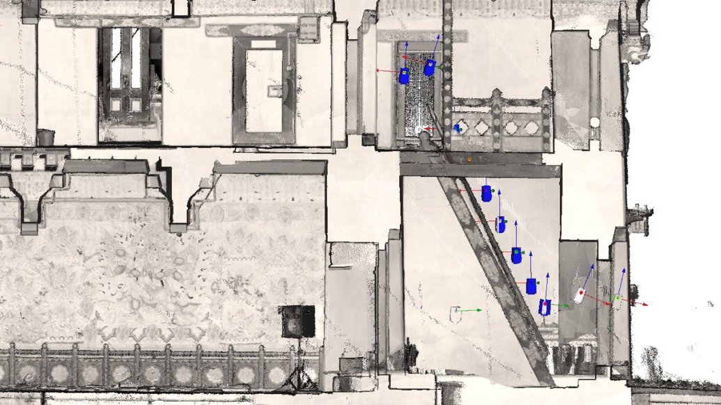
For the survey, a setup consisting of the VZ-600i 3D terrestrial laser scanner paired with a mounted Sony ILX-LR1 camera on a tripod was used, allowing efficient and precise data capture even within the dynamic environment of the monastery.
Advanced Technology: The VZ-600i's Camera Capabilities
By combining the built-in and/or mounted camera with the laser scanner, the resulting point cloud can be colorized to ensure a realistic visualization of the site. This greatly enhances the ability to identify objects and surfaces during review and post-processing.
With the RIEGL VZ-600i, image capture can occur simultaneously with the scanning process, which not only saves time when working with a large number of scan positions but is also essential in environments that are constantly in motion. If images and scans were captured separately, objects or people might appear in different locations, reducing the consistency and reliability of the dataset.


For indoor environments, an external camera offers advantages over built-in systems. It delivers better image quality in low-light conditions and performs especially well when capturing images simultaneously with the scan data. It is also less affected by mixed lighting sources, such as indoor LED fixtures, resulting in cleaner and more accurate imagery.
Four Intensive Days: Data Acquisition and Processing
At the selected standard resolution of 34 mdeg – or a 6 mm point spacing at 10 m– and with image capture performed during scanning, the acquisition time for a single scan position takes less than a minute. Due to the high degree of overlap, the resolution of the overall point cloud (composed of the individual scans) and the resulting average point spacing are ultimately much better than the 6 mm spacing of the individual scans.
Over the course of four days, 1,121 individual 360°-scans, including images, were captured. Registration of the individual scan positions was carried out directly and automatically within the scanner. In this voxel-based registration process, the individual scans are aligned with each other almost in real time using data from various built-in sensors. This saves a tremendous amount of time in the subsequent processing steps.
A Multi-Station Adjustment for the entire project is then performed in the RiSCAN PRO post-processing software. This step eliminates potential misalignments and, if necessary, incorporates externally surveyed control points.
In addition to the monastery’s continuous activity, the weather also posed challenges: in the afternoons, fresh and often heavy rainfall regularly swept down from the higher regions of the Himalayas. Narrow, winding spaces and connections via steep, tight stairways required both physical endurance and sustained concentration throughout the entire workflow.


Outlook and Acknowledgments
For the Kingdom of Bhutan, this first laser scanning project represents an important step towards modernization the documentation of cultural heritage. It provides local authorities, heritage conservationists, and engineers with an accurate and long-lasting data foundation for future planning.
At the same time, this project demonstrates the capabilities of a modern RIEGL terrestrial laser scanner. With its combination of high speed, precision, and integrated sensor and software workflows, the VZ‑600i provides exactly what is required for a project of this scale and detail.
We would like to express our sincere gratitude to His Holiness the Ninth Gangteng Rinpoche for granting us the opportunity to carry out data acquisition at such a unique site. His vision made both the project and the digital preservation of this cultural heritage possible.
Our thanks also go to Jigdrael Shenphen Namgyel, the co-author of this article. His close connection to the Kingdom of Bhutan – particularly to the Gangtey Monastery – opened the doors for this collaboration, and his professional organization and support made this extraordinary journey possible.


