

TERRESTRIAL LASER SCANNING
RIEGL VZ-4000i25
With the VZ-4000i25 RIEGL now presents the long-range version scanner of their latest generation of professional terrestrial laser scanners. It stands for an increase in productivity, reliability in performance, extreme versatility and new forms of connectivity– resulting in an excellent return of investment.

The Ultimate Long Range Laser Scanner
On-board processing, one-touch-button operation, customized workflows and pre-settings, as well as real-time registration enabled by GNSS/IMU provide a fast and efficient workflow from data acquisition to post-processing results. This scanner provides remarkable long-range performance of up to 4,600 m at eye safe operation in laser class 1. The IP64 certification ensures that it can be used in harsh environments. RIEGL’s Ultimate LiDAR technology provides multiple-target capability and valuable data attributes for every measurement. The versatility of the scanner allows the use in various applications and survey routines.
An internal camera, internal IMU for pose estimation, an optional external GNSS RTK receiver, support for user apps, and pre-installed RIEGL apps are further key features. Integrated WiFi, high-speed data download via TCP/IP, automatic and fast data transfer with CF-express card, cloud data synchronization via internet and exchange formats for further analysis provide brilliant connectivity.
For operating the scanner and for data processing, RIEGL offers the well-established software package RiSCAN PRO. Different license levels and plugin module licenses allow an adaption to the user specific requirements.
Main Features
- superior long range performance up to 4600 m
- extremely fast data acquisition
- straight-forward on-board processing
- one-touch button operation
- customized workflows and settings
- pre-installed RIEGL apps
- prepared for user specific Python apps
- internal IMU for pose estimation
- internal camera
- integrated WiFi
- high speed data download and transfer
- eye safe operation (Laser Class 1)
- especially for harsh environment (IP64 certified)

Main Applications
- Surveying and Monitoring in Mining
- Topography (DEM/DTM generation, risk assessment, and spatial analysis)
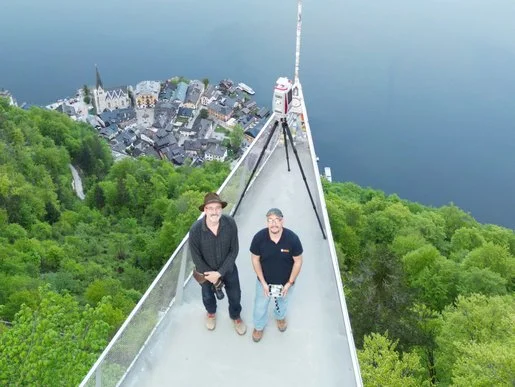
- Cultural Heritage Documentation
- Natural Heritage Documentation
Technical Data Overview
| Laser Pulse Repetition Rate PRR (peak) | 70 kHz | 150 kHz | 300 kHz | 500 kHz |
|---|---|---|---|---|
| Max. Measuring Range (p ≥ 90%) | 4600 m | 3100 m | 2350 m | 2000 m |
| Max. Measuring Range (p ≥ 60%) | 4000 m | 2700 m | 2000 m | 1700 m |
| Max. Measuring Range (p ≥ 20%) | 2550 m | 1700 m | 1250 m | 1000 m |
| Minimum Range | 5 m | 5 m | 5 m | 5 m |
| Max. Number of Targets per Pulse | 15 | 15 | 15 | 15 |

Software for RIEGL VZ-4000i25
We complement our high-performance hardware with innovative software packages to create powerful solutions for demanding applications. The RIEGL software packages are exclusively bundled with the appropriate RIEGL laser scanners and laser scanning systems. For this RIEGL product we provide:
For use with the RIEGL VZ-4000i25, special plugins, apps, and libaries are provided :
- RiPANO
to explore your project and to extract plots in your browser - RIEGL LIS GeoTec Plugin
for geotechnical analysis of scanned rock surfaces - RIEGL VZ-i Series App
to control your RIEGL VZ-i Series laser scanner system remotely - RIEGL VZ-i Monitoring Apps
for real-time analysis and data processing in diverse monitoring and mining applications - RiVLib
for developing custom software - RDBLib
for reading and writing various types of data
Download Area & Further Information
RIEGL VZ-4000i25
Case Studies
RIEGL VZ-4000i25
Gallery
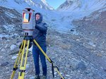
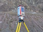

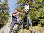

RIEGL VZ-4000i25
News & Insights


CONTACT
Get in touch.
Our team is happy to answer any questions you may have about RIEGL products and solutions. For technical support or general inquiries, please use the contact details below.
Technical Support:
support@rieglusa.com
+1 (407) 248 9927
+1 (321) 474 2518 (After Hours)
General Questions:
info@rieglusa.com
+1 (407) 248 9927
Looking for more information?
Send us your request using the product inquiry form.