
MOBILE LASER SCANNING
RIEGL VMY-1
The RIEGL VMY-1 is an extremely compact, economically priced Mapping System of small dimensions, that is well suited for a variety of basic mobile mapping applications.
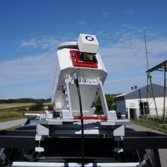
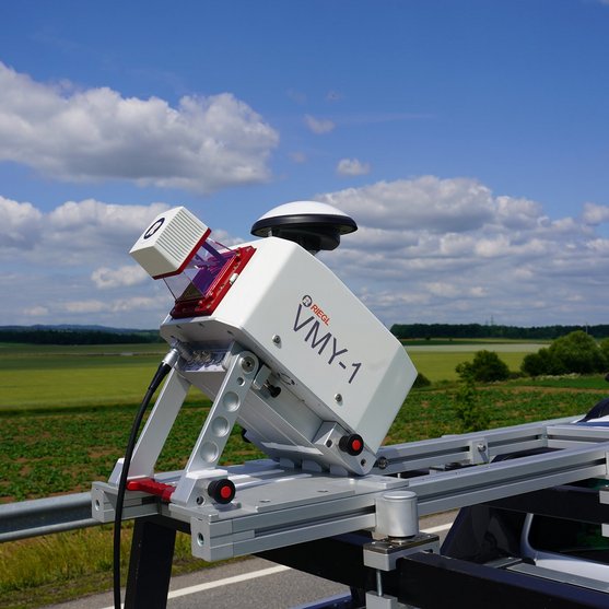
Extremely Compact Single Scanner Mobile Mapping System
The central part of the VMY-1 Mobile Mapping System is the RIEGL miniVUX-HA LiDAR sensor and an optional, high performance imaging system that complements the measurement data. The innovative design enables folding for convenient transport and space-saving storage. An easy-to-use interface, accessible via laptop, and the RIEGL data acquisition software facilitate the operator's task in the field by providing real-time visualization of the acquired scan data and imagery. The compact system is also ready for quick redeployment on a UAV within minutes.
The VMY-1 is ideally suited for asset management, utility mapping, and for application with smaller mobile platforms such as boats, bikes and all-terrain vehicles. Its light weight and compact design make it a great system for small and large acquisition programs.
Main Features
NEW SURVEY-GRADE SCANNER PERFORMANCE
- 4 mm Precision / 5 mm Accuracy
- Laser pulse repetition rate of up to 300 kHz
- Up to 150 scan lines per second
- Range 270 m
- Eye safe operation at Laser Class 1
- Field of view 360°
- Multiple target capability
- Optional integration of up to four cameras
Main Applications
- GIS Mapping and Asset Management
- Transportation Infrastructure Mapping
- HD Mapping for Autonomous Vehicles
- City Modeling
- Rapid Capture of Construction Sites and Bulk Material
- Open-Pit Mine Surveying
- As-Built Surveying
Technical Data Overview
| Effective Measurement Rate | 100 kHz | 200 kHz | 300 kHz |
|---|---|---|---|
| Max. Range, Target Reflectivity (p ≥ 80%) | 270 m | 240 m | 200 m |
| Max. Range, Target Reflectivity (p ≥ 60%) | 240 m | 210 m | 170 m |
| Max. Range, Target Reflectivity (p ≥ 20%) | 140 m | 120 m | 100 m |
| Minimum Range | 1 m | 1 m | 1 m |
| Max. Number of Targets per Pulse | 5 | 5 | 5 |
| Accuracy / Precision | 5 mm / 4mm | 5 mm / 4mm | 5 mm / 4mm |
Software for RIEGL VMY-1
We complement our high-performance hardware with innovative software packages to create powerful solutions for demanding applications. The RIEGL software packages are exclusively bundled with the appropriate RIEGL laser scanners and laser scanning systems. For this RIEGL product we provide:
These RIEGL software packages are complemented by special libraries (RiVLib, RDBLib) and plugins (RiMAP Plugin for ArcGIS).
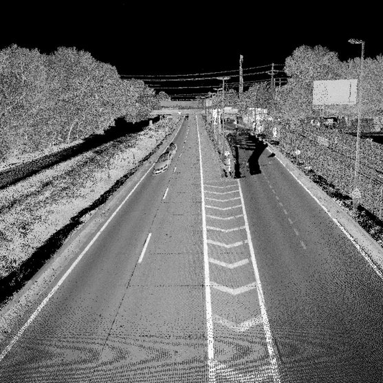
Explore some selected pointcloud samples.
RIEGL VMY-1
Gallery


CONTACT
Get in touch.
Our team is happy to answer any questions you may have about RIEGL products and solutions. For technical support or general inquiries, please use the contact details below.
Technical Support:
support@rieglusa.com
+1 (407) 248 9927
+1 (321) 474 2518 (After Hours)
General Questions:
info@rieglusa.com
+1 (407) 248 9927
Looking for more information?
Send us your request using the product inquiry form.