
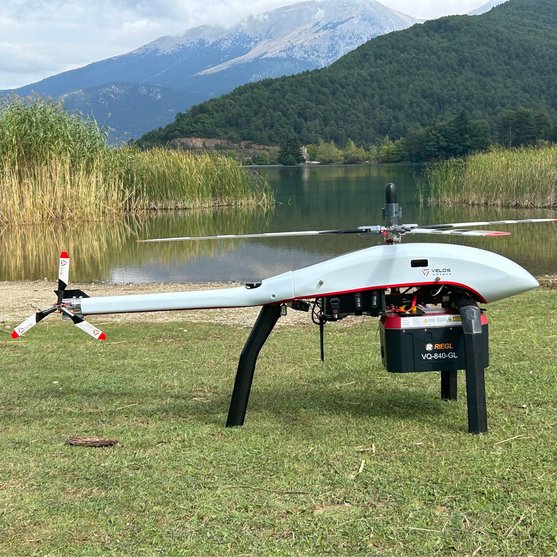
BATHYMETRY LASER SCANNING
RIEGL VQ-840-GL
The RIEGL VQ-840-GL is a fully integrated, compact airborne laser scanner for combined topographic and bathymetric surveying. The proven form factor and the use of very lightweight material make the VQ-840-GL suitable for integration into crewed aircraft and UAVs. VQ-840-GL offers customer specific initial system configurations and a large choice of parameter settings to enable mission tailored operation.
WITH ONLINE WAVEFORM PROCESSING AND FULL WAVEFORM RECORDING
Versatile Topo-Bathymetric Airborne Laser Scanner
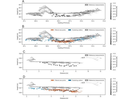
The scanner carries out laser range measurements for high resolution surveying of underwater topography with a narrow, visible green laser beam, emitted from a pulsed laser source. Subject to clarity, at this particular wavelength the laser beam penetrates water enabling measurement of submerged targets.
The distance measurement is based on the time-of-flight measurement with very short laser pulses and subsequent echo digitization and online waveform processing. To handle target situations with most complex multiple echo signals, beside the online waveform processing the digitized echo waveforms can be stored for subsequent off-line full waveform analysis. The laser beam is deflected in an elliptic scan pattern and hits the water surface at an incidence angle with low variation.
The VQ-840-GL can be complemented with an inertial navigation sensor for subsequent estimation of the instrument's location and orientation. As a further option a high-resolution digital camera can be integrated. The rugged internal mechanical structure together with the dust- and splash water proof housing enables long-term operation on airborne platforms.
Main Features
- for combined topographic and bathymetric airborne and UAV-based survey
- high accuracy ranging based on echo digitization and online waveform processing with multiple-target capability
- concurrent comprehensive full waveform storage for all measurements for subsequent full waveform analysis and waveform averaging tasks
- high spatial resolution due to measurement rate of up to 200 kHz and high scanning speed of up to 100 scans/sec
- integrated inertial navigation system (optional)
- integrated digital camera (optional)
- compact, lightweight and robust housing compliant with typical hatches in aircrafts and with stabilized platforms

Main Applications
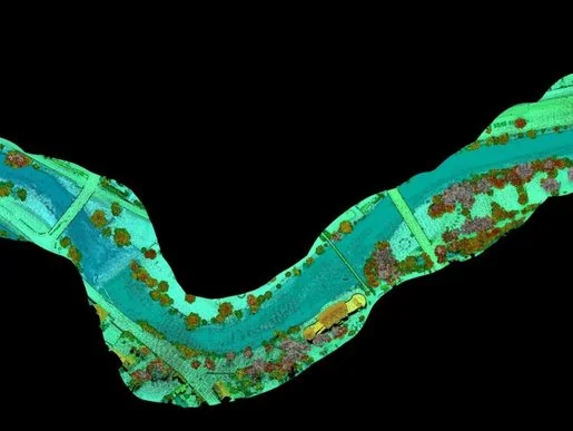
- Coastline and Shallow Water Mapping
- Surveying for Hydraulic Engineering
- Hydro-Archaeological-Surveying
- River Surveying
- Repeated Survey of Water Reservoirs
Technical Data Overview
| Measurement Rate | 200 kHz | 100 kHz | 50 kHz |
|---|---|---|---|
| Max. Water Depth Penetration in Secchi Depths | 1.7 | 1.8 | 2.0 |
| Minimum Range | 20 m | 20 m | 20 m |
| Accuracy / Precision | 20 mm / 15 mm | 20 mm / 15 mm | 20 mm / 15 mm |
| Laser Wavelength | 532 nm, green | 532 nm, green | 532 nm, green |
Software for RIEGL VQ-840-GL
We complement our high-performance hardware with innovative software packages to create powerful solutions for demanding applications. The RIEGL software packages are exclusively bundled with the appropriate RIEGL laser scanners and laser scanning systems. For this RIEGL product we provide:
For smooth processing of scan data acquired with RIEGL Hydrography Laser Scanners the Airborne Data Processing Software AddOn RiHYDRO is offered as supplement to RiPROCESS.
The RIEGL software packages are further complemented by special libraries (RiVLib, RDBLib) and plugins (RiMAP Plugin for ArcGIS).
RIEGL VQ-840-GL
Case Studies


CONTACT
Get in touch.
Our team is happy to answer any questions you may have about RIEGL products and solutions. For technical support or general inquiries, please use the contact details below.
Technical Support:
support@rieglusa.com
+1 (407) 248 9927
+1 (321) 474 2518 (After Hours)
General Questions:
info@rieglusa.com
+1 (407) 248 9927
Looking for more information?
Send us your request using the product inquiry form.