CASE STUDY
Tham Luang Cave Case Study | Cave Mapping Using RIEGL LiDAR Scanners
Discover how LiDAR technology helped prevent future disasters through a detailed map of Tham Luang Cave, created after the 2018 Thai Cave Rescue.

Following the extraordinary Thai Cave Rescue in 2018, a cave map of Tham Luang was vital for preventing future disasters. Use of a laser scanner for cave mapping resulted in an amazing 3D simulation of the entire cave system.
Tham Luang Cave System Mapping: How it Started
After completing several cave mapping projects with the aid of the RIEGL VZ series laser scanner, Commendium was contacted by MSP TV to assist with an episode of Drain the Oceans, titled Thai Cave Rescue. Commendium is a UK-based 3D surveying company that has previously mapped several underground systems.
Commissioned by National Geographic TV , the documentary follows the story of a youth football team and their coach exploring Thailand’s Chiang Rai province, and tragically getting trapped deep inside the cave for 17 days due to heavy rainfall.
A multi-disciplinary rescue party of up to 10,000 showed up to the scene. While the disaster hit exploration led to the tragic loss of two lives, the boys and their coach were ultimately rescued from the cave.
Tham Luang Cave Mapping Brief
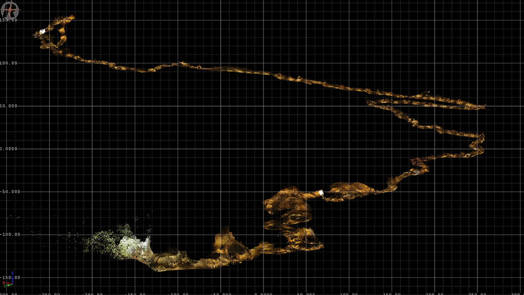
Commendium was tasked with surveying the 6-kilometre Tham Luang Cave in Thailand using LiDAR terrestrial scanners. The expert team turned the captured data into a photorealistic CGI 3D model of the cave journey using stitching, animations, and special effects.
The final product is the first accurate Tham Luang cave map ever created. Its detailed scans, extracted and enhanced by 3D effects experts, provide a vivid look inside the cave and even shows how water flows through the cave.
The Cave Mapping Process
The underground environment prevented standard geospatial tools from working. This included GNSS (Global Navigation Satellite System), a satellite navigation system used for precise determination of 3D location that land surveyors often use to track scanners over long, external corridor surveys. Consequently, the team had to use an internal, progressive cave mapping process to capture the Tham Luang cave system instead.
The Multi-Station Adjustment point cloud registration tools in RiSCAN PRO, —referred to as the ‘cave scanner software’ during the project—were instrumental in generating a high-resolution Tham Luang cave map. This process involved:
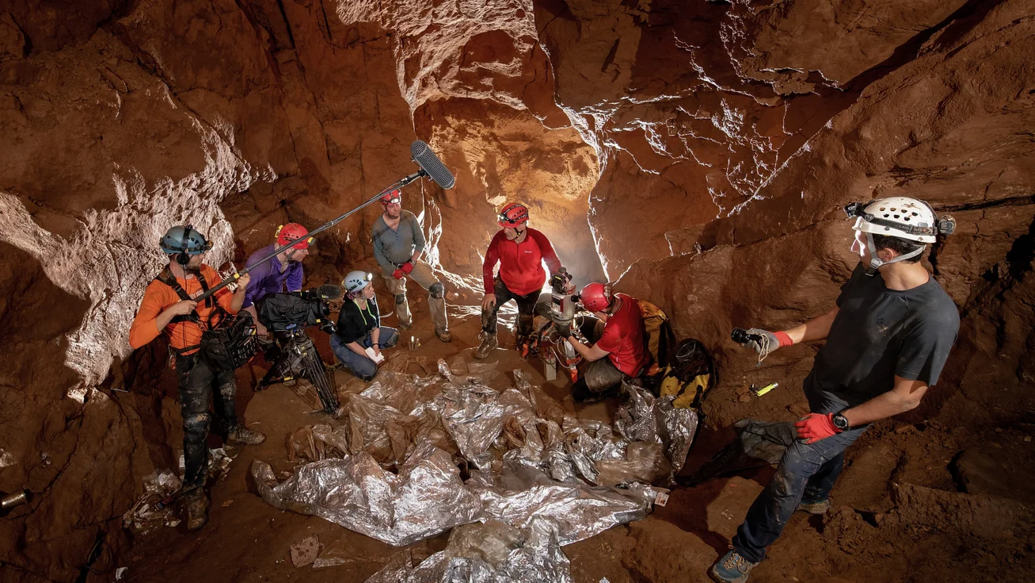
- Careful placement of scanners: Placing approximately 500 scanning stations throughout the cave, with each individual RIEGL cave scanner positioned optimally to ensure a 360° capture of localised nooks, crannies and natural detail
- Scanner overlaps: Carefully overlapped scan zones ensured full coverage and tight point cloud registration of the cave
- Extensive experience: Experienced analysts used RIEGL’s novel registration techniques to allow for the creation of a highly accurate 3D model with minimalised distortions or misalignments
- Overground Land Survey: An overground topographical survey was undertaken in part to provide geo-localisation at the cave openings.
Post-production: Cave Mapping & 3D Effects
Upon returning to the UK, the team began processing and integrating the imagery and 3D laser scan data to produce an intricate and detailed cave map. This involved:
- Colour adjustment: Toning colours of all images to create consistency and a natural look
- Fine-tuning brightness levels: Refining brightness for a balanced exposure in the images
- Point cloud cleaning: Removing dust, people, and other distractions from the 3D scans
- Refining the deliverable: Bringing images and laser scans together as a common visual data model.
RIEGL’s Tham Luang Cave Map: Laser Scanning, CGI & The Final Product
Working with talented visual effects experts over a period of weeks, the crew used laser scanning data to build several CGI models for the film. This included an animated diver, and the reconstruction of segments of the cave using CGI.
The final result is a highly detailed and eye-catching Thai cave rescue map featured in Drain The Oceans Series 2: Thai Cave Rescue, originally available on the Disney Channel.