NEWS, TECHNOLOGY, PARTNER
60 Kilometers in One Day: RIEGL Technology Powers Seamless Model of Austria’s Piesting River
Equipped with RIEGL’s VUX‑120 and VQ‑840‑G sensors, the South Tyrolean service provider Alto Drones generated a seamless terrain model of the Piesting River to aid hazard zone planning in Lower Austria.

The Project: Precise Data for Hazard Zone Planning and Flood Protection
As part of a federally funded hazard zone planning initiative, the surveying company Alto Drones GmbH, based in South Tyrol in Northern Italy, was commissioned in December 2024 to survey the Piesting river - flowing through the Lower Austrian Alpine Foreland and the Vienna Basin - using state-of-the-art RIEGL LiDAR technology. The project provides essential data for spatial and land-use planning, water management decisions, and the deployment of effective flood protection measures, while also helping to raise public awareness of flood risk.
For this airborne survey, Alto Drones used high-performance RIEGL laser scanning systems, collecting the data by helicopter.
“We appreciate the proven precision and reliability of RIEGL systems, which we can rely on for all new, challenging surveying projects. Our successful partnership with RIEGL is one of the reasons for our success – we would not want to be without it.”
RIEGL, one of the world’s leading providers of LiDAR surveying sensors and systems, headquartered in Horn, Lower Austria, is particularly pleased that its proprietary technology is being used in this project, thereby supporting public institutions in their efforts to maintain and enhance safety and resilience.

The Field Operations: Efficient Data Acquisition and Analysis
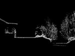
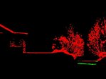
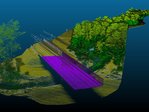
February 2025 provided ideal measurement conditions: low water discharge, minimal snow cover, and sparse vegetation. For the survey, a helicopter was equipped with two high-resolution airborne laser scanners – a RIEGL VQ‑840‑G for bathymetry and a RIEGL VUX‑120 for topography – along with an RGB nadir camera. Several overlapping flight strips were flown at an altitude of 200 meters above ground level. In a single day, more than 60 kilometers of river course were surveyed, covering a corridor with an average width of 100 meters.

After the survey flight, the trajectories of both scanners were calculated using RIEGL’s RiPROCESS software. The resulting point clouds were then registered and georeferenced using reference surfaces. Based on the measured water surface, refraction correction of the underwater points was performed in RiHYDRO, also part of the RIEGL software suite.
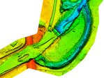
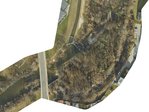
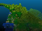
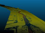
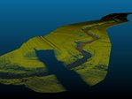
The Result: Seamless Terrain Models
The combined point clouds were classified, and several raster elevation models were derived, including a Digital Terrain Model (DTM) and a Digital Surface Model (DSM). For the first time, a complete topographic survey of both the dry and submerged sections of the Piesting River over a distance of more than 60 kilometers is now available.


The Outlook: Informative Base Data with Diverse Applications
The success of the Piesting project demonstrates the strong potential of airborne LiDAR technology for rapid and highly precise mapping of watercourses. Beyond its value for hazard zone planning, the technology also enables new applications in environmental monitoring, flood protection, and sustainable water management.
“The data acquired as part of this project provides valuable information about the current state and ongoing changes of the riverbed, thereby forming as an important basis for future planning in flood protection and hazard zone management in Lower Austria.”


About Alto Drones
Alto Drones has extensive experience in the use of LIDAR in airborne surveying: the company first began working with laser scanning systems for topographic surveying back in 2018. Initially, data was collected using a RIEGL miniVUX-1-UAV on an octocopter, which was soon followed by a second system.
Since 2021, the RIEGL VUX-120 has been used for drone- and helicopter-based operations. In 2023, the portfolio was expanded with a RIEGL VQ-840-G for bathymetric surveys. Over the past two years, the more powerful sensors RIEGL VUX‑160 and RIEGL VQ‑860‑G have also been added.
Through continuous consideration of customer needs and the ongoing integration of new sensors available on the market, Alto Drones is now excellently equipped for topo-bathymetric surveys across a wide range of applications.


