
MOBILE LASER SCANNING
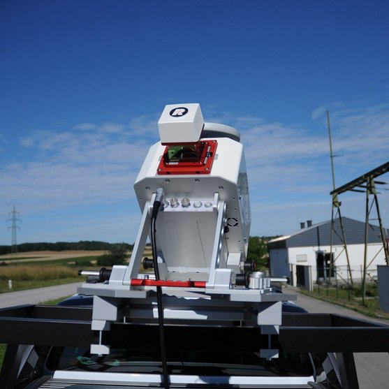
RIEGL miniVUX-HA
RIEGL’s proven miniVUX-Series of LiDAR sensors now further expands: With the RIEGL miniVUX-HA a new LiDAR sensor especially suited for applications in mobile laser scanning is provided. The extremely lightweight and compact sensor comes in a robust aluminum housing and offers itself as the core part of small, user-friendly, and economically priced kinematic laser scanning systems.

LiDAR Sensor for KINEMATIC Laser Scanning
RIEGL’s state-of-the-art Waveform-LiDAR technologies provide pure digital LiDAR signal processing, multiple targets per laser shot enabling the penetration of dense foilage, calibrated amplitudes and reflectance estimates and thus highly accurate, extremely informative measurement data. Scan data can be stored on the easy-to-remove SD card and/or streamed via LAN-TCP/IP interface.
The RIEGL miniVUX-HA provides up to 300,000 meas./sec, 150 lines/sec scan speed, 360° field of view, and 5 mm accuracy – these features allow the kinematic acquisition of laser scan data in a wide range of applications.
The sensor is offered as the core part of the RIEGL VMY Mobile Mapping Systems VMY-1 and VMY-2, which are fully integrated with IMU/GNSS and optional cameras.
Main Features
SURVEY-GRADE PERFORMANCE
- 5 mm accuracy
- 4 mm precision
- 100 kHz / 200 kHz / 300 kHz Laser PRR selectable
- measurement rate up to 300,000 measurements/sec
- scan speed up to 150 scans/sec
- minimum range 1 m
- very compact & lightweight (1.85 kg / 4.1 lbs)
- up to 360° field-of-view
- robust aluminum housing
- makes use of RIEGL’s unique echo signal digitization and online waveform processing
- multiple target capability – up to 5 target echoes per laser shot
- mechanical and electrical interface for IMU mounting
- user-friendly, application- and installation-oriented solutions for integration

Main Applications
- Transportation Infrastructure Mapping
- City Modeling
- As-Built Surveying
- GIS Mapping and Asset Management
- Rapid Capture of Construction Sites and Bulk Material
- Open-Pit Mine Surveying
Technical Data Overview
| Laser Pulse Repetition Rate PRR | 100 kHz | 200 kHz | 300 kHz | 300 kHz / 120°FOV |
|---|---|---|---|---|
| Max. Measuring Range (p ≥ 20%) | 140 m | 120 m | 100 m | 140 m |
| Max. Measuring Range (p ≥ 60%) | 240 m | 210 m | 170 m | 240 m |
| Max. Measuring Range (p ≥ 80%) | 270 m | 240 m | 200 m | 270 m |
| Minimum Range | 1 m | 1 m | 1 m | 1 m |
| Max. Number of Targets per Pulse | 5 | 5 | 5 | 5 |
| Accuracy / Precision | 5 mm / 4 mm | 5 mm / 4 mm | 5 mm / 4 mm | 5 mm / 4 mm |
Software for RIEGL miniVUX-HA
We complement our high-performance hardware with innovative software packages to create powerful solutions for demanding applications. The RIEGL software packages are exclusively bundled with the appropriate RIEGL laser scanners and laser scanning systems. For this RIEGL product we provide:
These RIEGL software packages are complemented by special libraries (RiVLib, RDBLib) and plugins (RiMAP Plugin for ArcGIS).
Explore some selected pointcloud samples.
Download Area & Further Information

CONTACT
Get in touch.
Our team is happy to answer any questions you may have about RIEGL products and solutions. For technical support or general inquiries, please use the contact details below.
Technical Support:
click here
General Questions:
sales@riegl.co.uk
+44 (0) 1904 217785
Looking for more information?
Send us your request using the product inquiry form.