
General
Photogrammetry creates 3D models from overlapping images and depends on light, texture, and image overlap.
LiDAR uses laser pulses to measure distances directly and generate precise 3D point clouds. It is even possible to “see through” vegetation thanks to the multi target capability. For example, RIEGL LiDAR systems are particularly well-suited for mapping terrain, forested areas, infrastructure, and corridors, where reliable geometry is always more important than the appearance of the resulting images. In addition, LiDAR measurements are not dependent on daylight, which means that lidar surveys can also be conducted at night.
Full-waveform LiDAR records the complete reflected laser signal of each pulse instead of only selected return points (pulses). This helps detect multiple targets along the laser path and provides richer information about vegetation, terrain, and object structure. For example, RIEGL waveform-based systems are used in forestry, for airborne mapping, and for complex infrastructure surveys where target separation is of critical importance.
RIEGL LiDAR technology combines waveform processing, high measurement accuracy, long-range performance, and robust system integration. The result is reliable 3D data capture in demanding environments such as dense vegetation, open-pit mines, extensive transport corridors, and multifaceted coastal zones. Based on RIEGL LiDAR technology RIEGL’s high performance terrestrial, mobile, airborne, UAV-based, topo-bathymetric and industrial sensors and systems deliver highly precise and reliable measurement data.
RIEGL products are developed, manufactured, and tested in Austria. The company’s headquarters in Horn, Lower Austria, support research, development, production, testing, sales, training, and administration. This in-house approach helps ensure consistent quality, reliable performance, and long product lifecycles.
A fully integrated RIEGL system combines LiDAR sensor, IMU/GNSS unit and, if wished, camera options and is received in a fully calibrated and ready to use condition by the customer. Provision of the appropriate RIEGL software packages for data processing and geo-referencing of the acquired data by means of an optimized workflow completes the overall solution. Receiving a fully integrated and calibrated system solution improves data consistency, and simplifies acquisition and processing procedures. For example, the RIEGL VUX-820-G is offered as a fully integrated “all-in” topo-bathymetric package with RiLOC-F-inside IMU/GNSS unit, an integrated RGB camera, and software for generating georeferenced and refraction-corrected point clouds.
Yes, within given boundaries, RIEGL systems can be configured for specific platforms, applications, and workflows, including sensor selection, camera integration, IMU/GNSS options, mounting concepts, and software setup. For example, VUX-series sensors can be used as stand-alone UAV LiDAR sensors and integrated into customer-specific configurations, or they can be supplied as fully integrated systems with IMU/GNSS and optional cameras for straight-forward deployment on drones.
RIEGL TLS (Terrestrial Laser Scanning) is performed from a stationary position and captures static highly detailed 3D data from the ground.
RIEGL MLS (Mobile Laser Scanning) uses LiDAR technology for the acquisition of kinematic high-accuracy data. The scanner is mounted on moving platforms (cars, boats, trains) and captures measurement data in driving by.
RIEGL ULS (UAV-based Laser Scanning) uses drones for flexible high-resolution surveys.
RIEGL ALS (Airborne Laser Scanning) allows the acquisition of kinematic data from large areas from aircraft.
RIEGL BLS (Bathymetric Laser Scanning) or RIEGL ALB (Airborne LiDAR Bathymetry) maps both land and shallow water areas.
UAV LiDAR is ideal for smaller areas, complex terrain, low-altitude missions, and projects requiring very high point density or flexible deployment. Airborne LiDAR is the right choice for large-area mapping from high altitudes. For example, a RIEGL UAV LiDAR sensor can support high-density UAV corridor mapping, while RIEGL airborne mapping systems are designed for large-scale airborne surveys using manned aircraft like planes or helicopters.
Yes. RIEGL scanners and systems support external or some models also support integrated cameras to acquire image data for colorization of point clouds, image documentation, and sensor fusion workflows in post-processing. Individual camera options are given in the appropriate RIEGL datasheets.
RIEGL systems are developed and manufactured in Austria and generally meet strict requirements regarding procurement and security.
Compliance with the NDAA standards should always be confirmed for the specific product, configuration and project requirements. For projects in the United States, the local team at RIEGL USA can provide the relevant compliance documentation.
RIEGL offers dedicated topo-bathymetric sensors and systems for simultaneous mapping of topography and underwater terrain in shallow-water environments. Depending on the project-specific requirements regarding flight altitude, platforms, geographical and temporal scope, you may choose from RIEGL’s ALB (Airborne Laser Bathymetry) portfolio, given in the product segment Bathymetric Scanning.
The VZ-600i provides
- Internal 2 TB drive
- Removable 512 GB CF Express card (included in the scanner basic configuration)
- Removable 1 TB CF Express card (optional – Accessory List)
Ranging Accuracy = 5mm (1-sigma value @ 100 m range under RIEGL test conditions. / Accuracy is the degree of conformity of a measured quantity to its actual (true) value.)
3D Position Accuracy = 3 mm @ 50 m, 5 mm @ 100 m (1-sigma value, based on target modelling, under RIEGL test conditions.)
The biggest factors affecting accuracy are atmospheric conditions such as air pressure / humidity / temperature. These values are measured at the location of the laser scanner.
The VZ-400i – successfully in use for many years worldwide – is a very robust 3D terrestrial laser scanner providing up to 800 m measurement range. The VZ-600i is RIEGL’s most versatile laser scanner based on RIEGL’s latest developments in LiDAR technology and provides a measurement range of up to 1000 m and an extremely high measurement speed for the acquisition of high-accuracy and reliable 3D data in a wide range of applications. The RIEGL VZ-1200i is its sister type providing an even larger measurement range of up to 1800 m for projects which need an extended range capability without having to sacrifice high-speed data acquisition.
The maximum range of a RIEGL TLS scanner depends on the model, measurement program, atmospheric conditions, and target reflectivity. For example, the RIEGL VZ-600i offers a range capability up to 1000 m, the RIEGL VZ-1200i can reach up to 1800 m in selected settings, and long-range models such as the RIEGL VZ-4000i25 are designed for even longer monitoring and terrain applications up to 4600 m. With a range of up to 6000 m, the RIEGL VZ-6000i26 is currently RIEGL's terrestrial 3D laser scanning system with the longest range.
Typical values for average conditions. Maximum range is specified for flat targets with size in excess of the laser beam diameter, perpendicular angle of incidence, and for atmospheric visibility of 23 km.
The TLS scan data is stored digitally on the RIEGL VZ-600i’s SSD. During scanning, the current project can be synchronized to the CF-express card. This means the card contains a copy of the current project immediately following the last scan position and can be transferred to a PC at speeds of up to 500 MBit/sec via a card reader without any loss of time. Further data processing is performed using the RiSCAN PRO PC software.
No, the RIEGL VZ-i ROS driver was developed exclusively for the RIEGL VZ-i series (VZ-400i, VZ-600i, VZ-1200i). ROS (Robot Operating System) is an open-source framework designed to help developers create robot applications. It offers a collection of software libraries, tools, and conventions that simplify the development of complex and robust robot behaviors across a wide range of robot platforms.
The RIEGL VZ-i ROS driver serves as a key interface between the RIEGL VZ-i series laser scanner mounted on a robot platform and the ROS software framework. It is required to translate raw sensor data and control commands into a format that ROS can understand and process. This enables seamless communication and coordination between various hardware components and the higher-level software modules.
GNSS RTK integration depends on the scanner model and configuration. Select RIEGL TLS systems support GNSS RTK for accurate positioning and georeferencing in the field. For example,
- RIEGL VZ-400i: RIEGL VZ-i GNSS RTK Receiver (datasheet) , while
- the RIEGL VZ-600i can use a RIEGL GNSS RTK Receiver, Ri-RTKM (accessory list).
The recommended maximum platform speed depends on required maximum line spacing and traffic limitation. Data is generally acquired under normal traffic flow conditions.
RIEGL sensors and systems support a wide range of target types, including:
- Rectangle
- Checkerboard
- Disk
- Chevron
- Hourglass
- Windmill
- Rail profile
All target types can be used in either horizontal or vertical orientation.
MLS operation depends on the system configuration and acquisition workflow. RIEGL mobile mapping systems are controlled and monitored through the dedicated acquisition software RiACQUIRE. It allows online visualization of geo-referenced monitoring, quality assurance, operator’s interactions and status feedback during data acquisition. For convenient and safe operation, all MLS systems can be easily operated with RiACQUIRE Operator Console with Haptic Shortcut Keys. Six haptic LCD buttons enable one finger touch system operation. Compared to touch-screen button control (e.g. on a mobile device), the haptic buttons allow orientation on the keyboard without direct eye contact.
Yes. RIEGL can support suitable mounting concepts and system integration for mobile laser scanning platforms. The appropriate solution depends on the MLS system, vehicle type, payload, application, and regional safety requirements.
A RIEGL MLS system can only be mounted on a roof rack if the rack and vehicle meet the required load, stiffness, vibration, and safety specifications. A typical setup is based on commercially available Thule Roof bars.
If the vehicle geometry requires the roof mount to be positioned further toward the rear in order to avoid scan shadows and to provide a more suitable camera mounting position for pavement imaging, the use of the RIEGL reinforced roof mount is recommended. The reinforced roof mount is supported by three roof bars. With two roof bars positioned at the rear, the mounting structure benefits from improved support, allowing the roof mount to extend further beyond the rear roof bar in a cantilevered configuration.
The recommended tool is RiPARAMETER, RIEGL's laser scanner configuration software. It calculates a consistent, valid set of acquisition parameters (altitude, speed, pulse repetition rate and more) for a desired point density and optimizes for maximum area rate at the same time. It enables the comparison of different RIEGL ALS/ULS systems against each other for a specific survey task — giving point density and area coverage rate for exact mission setup rather than a generic figure.
As a quick offline reference, RIEGL's airborne and UAV-based laser scanner datasheets also include diagrams showing achievable point density as a function of flying altitude and speed, together with the corresponding area coverage rate. These are useful for a first estimate, and the values they show can be cross-checked against the results from RiPARAMETER if a more precise figure is needed.
There is no single "typical" altitude: first and foremost it depends on the acquisition task and the desired point density. In practice, missions are flown anywhere from a few hundred metres up to several kilometres above ground level (AGL). The RIEGL VQ-1560III-S illustrates the upper end of that range: thanks to pulse repetition rates of up to 4.4 MHz, it can be operated at up to 1600 m AGL at maximum PRR, or up to 3900 m AGL at a reduced PRR of 560 kHz (figures quoted for 20% target reflectance). Lower-altitude, higher-density missions with the same or other RIEGL sensors are of course equally possible.
Temperature limits depend on the exact ALS model, installation, aircraft environment, and mission profile. RIEGL airborne scanners and systems are designed for professional and reliable field operation, the applicable standard operating and storage temperature ranges are available on the relevant datasheet and in the technical documentation.
The right choice depends on the aircraft's payload capacity, hatch size, available mount, power supply, and the point density and application the survey requires. RIEGL's compact scanners — such as the VQ-580 II-S, VQ-780 II-S, and VQ-680 — are specifically designed for integration into small hatches and gyro-stabilized mounts, and are routinely flown on single-engine piston aircraft, helicopters, and ultralights. As always, the final system selection should be confirmed with a RIEGL integration review that takes the specific aircraft and survey objectives into account.
Airborne LiDAR data combines laser measurements with precisely determined IMU/GNSS trajectory data, a method known as direct georeferencing. The RiPROCESS software suite performs raw scan data preparation, direct georeferencing, scan data adjustment and export. The resulting georeferenced point cloud serves as the basis for generating a wide range of mapping and surveying products.
Yes. RIEGL’s GeoSys Manager supports importing existing geodetic datums based on EPGS standards or fully customized engineering coordinate systems tailored to specific project requirements.
For multi-copter platforms, we recommend a flight speed of 8–10 m/s to ensure optimal data quality and system performance. For fixed-wing platform, the recommended cruise speed is around 20 m/s.
RIEGL’s RiLOC systems provide an integrated end to end RIEGL system workflow that removes the need for third party hardware or software. This reduces overall system investment while maintaining top performance and seamless compatibility across components.
A distinction must be made between the weight of the stand-alone sensor and the weight of the entire system. The lightest stand-alone RIEGL sensors are currently the miniVUX-series sensors, weighing 1.55 kg / 3.4 lbs. Depending on the task for which the sensor is used and which additional components - such as a camera and IMU/GNSS system - are employed to meet the requirements of the specific application, the system weight will vary and is not determined solely by the sensor’s weight.
To offer especially lightweight systems, RIEGL provides UAV LiDAR sensors with RIEGL’s proprietary IMU/GNSS System, RiLOC.
RIEGL airborne systems support different high-precision IMU/GNSS solutions depending on the scanner model, platform, and application. With RiLOC, the IMU/GNSS solution developed by RIEGL, fully integrated positioning options with an excellent cost-benefit ratio are offered.
Selected third-party systems, such as Trimble Applanix APX for UAV mapping or Applanix POS AV for airborne applications, can also be used. The RIEGL team will be happy to help you select the IMU/GNSS that best suits your system, your project setup and your project requirements.
What camera is recommended depends on application, image resolution, shutter type, lens, weight, synchronization, and platform payload. For example, VUX-series scanners support optional external cameras for colorization of the acquired measurement data; the VUX-12023 allows integration of up to two optional external cameras, while the VUX-18024 provides interfaces for up to five optional cameras. The final choice of camera should be made as part of the system integration process.
RiLOC is RIEGL's localization and orientation component for selected kinematic LiDAR systems, combining IMU/GNSS data and RIEGL workflow integration. Compared with third-party positioning systems such as Applanix, RiLOC is designed to provide tightly integrated positioning within the RIEGL ecosystem, while Applanix remains a widely used independent navigation solution across many sensor platforms. The best option depends on required accuracy, integration scope, existing equipment, and processing workflow.
RiLOC performance depends on GNSS conditions, IMU quality, trajectory geometry, and the availability of usable LiDAR surface information for refinement. Environments with few distinct features, repetitive geometry, or poor GNSS reception can reduce the amount of useful information for trajectory improvement. In these cases, good mission planning, local base station setup, overlap, and control data become especially important.
The Secchi depth method estimates water clarity based on the depth at which a standard black-and-white disk is no longer visible to the human eye. For bathymetric LiDAR survey missions, it provides a field indicator for expectable laser penetration. RIEGL bathymetric LiDAR systems’ underwater performance is expressed in Secchi depths for reasons of practicability and because the Secchi measurement is especially relavant in the shallow water area.
RIEGL BLS results can be validated through reference data or ground truth, if available, such as published cartographic data available from hydrographic offices, or data from complementary survey missions. The processing software for bathymetric data includes a TPU tool for estimating total propagated uncertainty, to check measurement quality and provide proof of conformity with a required standard.
RIEGL BLS systems are designed and developed for commercial topographic, hydrographic and bathymetric surveying applications. Due to the green laser used in bathymetric LiDAR systems, all RIEGL BLS scanners and systems are classified as dual use goods. They are subject to export restrictions classified as set up by the Wassenaar Arrangement. For details refer to the according datasheets.
RIEGL offers special protective housings for use in particularly harsh environments.
The PH-VUX, for example, is a protective housing sealed against dust and water jets according to IP65 , which enables the scanner to operate under stabilized temperature conditions thanks to integrated long-life thermo-electric elements and forced-air cooling.
Instead of a standard protective shelter for long-range scanners, applications requiring an even higher protection rating can utilize specialized enclosures.
For instance, the "ArmourCase" (achieving IP66) is available from third-party automation specialists (Syperion GmbH & Co. KG), which is specifically tailored to protect RIEGL laser scanners in the most demanding environments.
RIEGL scanners and systems meet model-specific protection ratings depending on the device, housing, and integration setup. For every device, the IP Protection Class according to EN60529 is given on the datasheet. Most standalone RIEGL devices meet IP64, meaning they are protected against contact, dust infiltration, and splash water from any direction.
However, when integrated into dedicated enclosures, protection levels increase significantly: the RIEGL PH-VUX protective housing features an IP65 rating, while specialized heavy-duty solutions like the Syperion Armour Case provide up to IP66 protection for extreme industrial or environments. Exact protection ratings should always be checked for the selected scanner configuration and the intended mission
Yes, in principle. RIEGL can upgrade existing systems. However, it is necessary to evaluate the current configuration beforehand to assess whether a modification or upgrade is feasible.
RiPARAMETER is a RIEGL software that helps operators of airborne laser scanning systems to define a consistent and valid parameter set for data acquisition. It supports mission planning by estimating performance-related parameters such as point density, coverage, flight altitude, scan settings, and acquisition geometry.
For quick and easy inspection of pointcloud data and imagery RiPROCESS and RiSCAN PRO come with embedded viewer engines. Data can be loaded by drag and drop and visualized by a variety of point attributes. To share terrestrial data for quick inspection, without the need to install one of the processing software packages, RiPANO is the recommended RIEGL tool. It allows users to explore point cloud projects, extract ortho views, and create plots for further use in CAD workflows. RiPANO is running plugin-free in a browser or as a stand-alone application on Windows and macOS.
For LiDAR data acquired with RIEGL’s topo-bathymetric scanners and systems, RiPROCESS with the RiHYDRO add-on is the key RIEGL software combination for detection of submerged targets. RiHYDRO extracts water surface models and applies refraction and runtime corrections to subsurface measurements, while RiPROCESS manages and processes the resulting georeferenced point cloud.
A fully integrated RIEGL system combines LiDAR sensor, IMU/GNSS unit and, if wished, camera options and is received in a fully calibrated and ready to use condition by the customer. Provision of the appropriate RIEGL software packages for data processing and geo-referencing of the acquired data by means of an optimized workflow completes the overall solution. Receiving a fully integrated and calibrated system solution improves data consistency, and simplifies acquisition and processing procedures. For example, the RIEGL VUX-820-G is offered as a fully integrated “all-in” topo-bathymetric package with RiLOC-F-inside IMU/GNSS unit, an integrated RGB camera, and software for generating georeferenced and refraction-corrected point clouds.
Yes, within given boundaries, RIEGL systems can be configured for specific platforms, applications, and workflows, including sensor selection, camera integration, IMU/GNSS options, mounting concepts, and software setup. For example, VUX-series sensors can be used as stand-alone UAV LiDAR sensors and integrated into customer-specific configurations, or they can be supplied as fully integrated systems with IMU/GNSS and optional cameras for straight-forward deployment on drones.
RIEGL TLS (Terrestrial Laser Scanning) is performed from a stationary position and captures static highly detailed 3D data from the ground.
RIEGL MLS (Mobile Laser Scanning) uses LiDAR technology for the acquisition of kinematic high-accuracy data. The scanner is mounted on moving platforms (cars, boats, trains) and captures measurement data in driving by.
RIEGL ULS (UAV-based Laser Scanning) uses drones for flexible high-resolution surveys.
RIEGL ALS (Airborne Laser Scanning) allows the acquisition of kinematic data from large areas from aircraft.
RIEGL BLS (Bathymetric Laser Scanning) or RIEGL ALB (Airborne LiDAR Bathymetry) maps both land and shallow water areas.
UAV LiDAR is ideal for smaller areas, complex terrain, low-altitude missions, and projects requiring very high point density or flexible deployment. Airborne LiDAR is the right choice for large-area mapping from high altitudes. For example, a RIEGL UAV LiDAR sensor can support high-density UAV corridor mapping, while RIEGL airborne mapping systems are designed for large-scale airborne surveys using manned aircraft like planes or helicopters.
Yes. RIEGL scanners and systems support external or some models also support integrated cameras to acquire image data for colorization of point clouds, image documentation, and sensor fusion workflows in post-processing. Individual camera options are given in the appropriate RIEGL datasheets.
RIEGL systems are developed and manufactured in Austria and generally meet strict requirements regarding procurement and security.
Compliance with the NDAA standards should always be confirmed for the specific product, configuration and project requirements. For projects in the United States, the local team at RIEGL USA can provide the relevant compliance documentation.
RIEGL offers dedicated topo-bathymetric sensors and systems for simultaneous mapping of topography and underwater terrain in shallow-water environments. Depending on the project-specific requirements regarding flight altitude, platforms, geographical and temporal scope, you may choose from RIEGL’s ALB (Airborne Laser Bathymetry) portfolio, given in the product segment Bathymetric Scanning.
The VZ-600i provides
- Internal 2 TB drive
- Removable 512 GB CF Express card (included in the scanner basic configuration)
- Removable 1 TB CF Express card (optional – Accessory List)
Ranging Accuracy = 5mm (1-sigma value @ 100 m range under RIEGL test conditions. / Accuracy is the degree of conformity of a measured quantity to its actual (true) value.)
3D Position Accuracy = 3 mm @ 50 m, 5 mm @ 100 m (1-sigma value, based on target modelling, under RIEGL test conditions.)
The biggest factors affecting accuracy are atmospheric conditions such as air pressure / humidity / temperature. These values are measured at the location of the laser scanner.
The VZ-400i – successfully in use for many years worldwide – is a very robust 3D terrestrial laser scanner providing up to 800 m measurement range. The VZ-600i is RIEGL’s most versatile laser scanner based on RIEGL’s latest developments in LiDAR technology and provides a measurement range of up to 1000 m and an extremely high measurement speed for the acquisition of high-accuracy and reliable 3D data in a wide range of applications. The RIEGL VZ-1200i is its sister type providing an even larger measurement range of up to 1800 m for projects which need an extended range capability without having to sacrifice high-speed data acquisition.
The maximum range of a RIEGL TLS scanner depends on the model, measurement program, atmospheric conditions, and target reflectivity. For example, the RIEGL VZ-600i offers a range capability up to 1000 m, the RIEGL VZ-1200i can reach up to 1800 m in selected settings, and long-range models such as the RIEGL VZ-4000i25 are designed for even longer monitoring and terrain applications up to 4600 m. With a range of up to 6000 m, the RIEGL VZ-6000i26 is currently RIEGL's terrestrial 3D laser scanning system with the longest range.
Typical values for average conditions. Maximum range is specified for flat targets with size in excess of the laser beam diameter, perpendicular angle of incidence, and for atmospheric visibility of 23 km.
The TLS scan data is stored digitally on the RIEGL VZ-600i’s SSD. During scanning, the current project can be synchronized to the CF-express card. This means the card contains a copy of the current project immediately following the last scan position and can be transferred to a PC at speeds of up to 500 MBit/sec via a card reader without any loss of time. Further data processing is performed using the RiSCAN PRO PC software.
No, the RIEGL VZ-i ROS driver was developed exclusively for the RIEGL VZ-i series (VZ-400i, VZ-600i, VZ-1200i). ROS (Robot Operating System) is an open-source framework designed to help developers create robot applications. It offers a collection of software libraries, tools, and conventions that simplify the development of complex and robust robot behaviors across a wide range of robot platforms.
The RIEGL VZ-i ROS driver serves as a key interface between the RIEGL VZ-i series laser scanner mounted on a robot platform and the ROS software framework. It is required to translate raw sensor data and control commands into a format that ROS can understand and process. This enables seamless communication and coordination between various hardware components and the higher-level software modules.
GNSS RTK integration depends on the scanner model and configuration. Select RIEGL TLS systems support GNSS RTK for accurate positioning and georeferencing in the field. For example,
- RIEGL VZ-400i: RIEGL VZ-i GNSS RTK Receiver (datasheet) , while
- the RIEGL VZ-600i can use a RIEGL GNSS RTK Receiver, Ri-RTKM (accessory list).
The recommended maximum platform speed depends on required maximum line spacing and traffic limitation. Data is generally acquired under normal traffic flow conditions.
RIEGL sensors and systems support a wide range of target types, including:
- Rectangle
- Checkerboard
- Disk
- Chevron
- Hourglass
- Windmill
- Rail profile
All target types can be used in either horizontal or vertical orientation.
MLS operation depends on the system configuration and acquisition workflow. RIEGL mobile mapping systems are controlled and monitored through the dedicated acquisition software RiACQUIRE. It allows online visualization of geo-referenced monitoring, quality assurance, operator’s interactions and status feedback during data acquisition. For convenient and safe operation, all MLS systems can be easily operated with RiACQUIRE Operator Console with Haptic Shortcut Keys. Six haptic LCD buttons enable one finger touch system operation. Compared to touch-screen button control (e.g. on a mobile device), the haptic buttons allow orientation on the keyboard without direct eye contact.
Yes. RIEGL can support suitable mounting concepts and system integration for mobile laser scanning platforms. The appropriate solution depends on the MLS system, vehicle type, payload, application, and regional safety requirements.
A RIEGL MLS system can only be mounted on a roof rack if the rack and vehicle meet the required load, stiffness, vibration, and safety specifications. A typical setup is based on commercially available Thule Roof bars.
If the vehicle geometry requires the roof mount to be positioned further toward the rear in order to avoid scan shadows and to provide a more suitable camera mounting position for pavement imaging, the use of the RIEGL reinforced roof mount is recommended. The reinforced roof mount is supported by three roof bars. With two roof bars positioned at the rear, the mounting structure benefits from improved support, allowing the roof mount to extend further beyond the rear roof bar in a cantilevered configuration.
The recommended tool is RiPARAMETER, RIEGL's laser scanner configuration software. It calculates a consistent, valid set of acquisition parameters (altitude, speed, pulse repetition rate and more) for a desired point density and optimizes for maximum area rate at the same time. It enables the comparison of different RIEGL ALS/ULS systems against each other for a specific survey task — giving point density and area coverage rate for exact mission setup rather than a generic figure.
As a quick offline reference, RIEGL's airborne and UAV-based laser scanner datasheets also include diagrams showing achievable point density as a function of flying altitude and speed, together with the corresponding area coverage rate. These are useful for a first estimate, and the values they show can be cross-checked against the results from RiPARAMETER if a more precise figure is needed.
There is no single "typical" altitude: first and foremost it depends on the acquisition task and the desired point density. In practice, missions are flown anywhere from a few hundred metres up to several kilometres above ground level (AGL). The RIEGL VQ-1560III-S illustrates the upper end of that range: thanks to pulse repetition rates of up to 4.4 MHz, it can be operated at up to 1600 m AGL at maximum PRR, or up to 3900 m AGL at a reduced PRR of 560 kHz (figures quoted for 20% target reflectance). Lower-altitude, higher-density missions with the same or other RIEGL sensors are of course equally possible.
Temperature limits depend on the exact ALS model, installation, aircraft environment, and mission profile. RIEGL airborne scanners and systems are designed for professional and reliable field operation, the applicable standard operating and storage temperature ranges are available on the relevant datasheet and in the technical documentation.
The right choice depends on the aircraft's payload capacity, hatch size, available mount, power supply, and the point density and application the survey requires. RIEGL's compact scanners — such as the VQ-580 II-S, VQ-780 II-S, and VQ-680 — are specifically designed for integration into small hatches and gyro-stabilized mounts, and are routinely flown on single-engine piston aircraft, helicopters, and ultralights. As always, the final system selection should be confirmed with a RIEGL integration review that takes the specific aircraft and survey objectives into account.
Airborne LiDAR data combines laser measurements with precisely determined IMU/GNSS trajectory data, a method known as direct georeferencing. The RiPROCESS software suite performs raw scan data preparation, direct georeferencing, scan data adjustment and export. The resulting georeferenced point cloud serves as the basis for generating a wide range of mapping and surveying products.
Yes. RIEGL’s GeoSys Manager supports importing existing geodetic datums based on EPGS standards or fully customized engineering coordinate systems tailored to specific project requirements.
For multi-copter platforms, we recommend a flight speed of 8–10 m/s to ensure optimal data quality and system performance. For fixed-wing platform, the recommended cruise speed is around 20 m/s.
RIEGL’s RiLOC systems provide an integrated end to end RIEGL system workflow that removes the need for third party hardware or software. This reduces overall system investment while maintaining top performance and seamless compatibility across components.
A distinction must be made between the weight of the stand-alone sensor and the weight of the entire system. The lightest stand-alone RIEGL sensors are currently the miniVUX-series sensors, weighing 1.55 kg / 3.4 lbs. Depending on the task for which the sensor is used and which additional components - such as a camera and IMU/GNSS system - are employed to meet the requirements of the specific application, the system weight will vary and is not determined solely by the sensor’s weight.
To offer especially lightweight systems, RIEGL provides UAV LiDAR sensors with RIEGL’s proprietary IMU/GNSS System, RiLOC.
RIEGL airborne systems support different high-precision IMU/GNSS solutions depending on the scanner model, platform, and application. With RiLOC, the IMU/GNSS solution developed by RIEGL, fully integrated positioning options with an excellent cost-benefit ratio are offered.
Selected third-party systems, such as Trimble Applanix APX for UAV mapping or Applanix POS AV for airborne applications, can also be used. The RIEGL team will be happy to help you select the IMU/GNSS that best suits your system, your project setup and your project requirements.
What camera is recommended depends on application, image resolution, shutter type, lens, weight, synchronization, and platform payload. For example, VUX-series scanners support optional external cameras for colorization of the acquired measurement data; the VUX-12023 allows integration of up to two optional external cameras, while the VUX-18024 provides interfaces for up to five optional cameras. The final choice of camera should be made as part of the system integration process.
RiLOC is RIEGL's localization and orientation component for selected kinematic LiDAR systems, combining IMU/GNSS data and RIEGL workflow integration. Compared with third-party positioning systems such as Applanix, RiLOC is designed to provide tightly integrated positioning within the RIEGL ecosystem, while Applanix remains a widely used independent navigation solution across many sensor platforms. The best option depends on required accuracy, integration scope, existing equipment, and processing workflow.
RiLOC performance depends on GNSS conditions, IMU quality, trajectory geometry, and the availability of usable LiDAR surface information for refinement. Environments with few distinct features, repetitive geometry, or poor GNSS reception can reduce the amount of useful information for trajectory improvement. In these cases, good mission planning, local base station setup, overlap, and control data become especially important.
The Secchi depth method estimates water clarity based on the depth at which a standard black-and-white disk is no longer visible to the human eye. For bathymetric LiDAR survey missions, it provides a field indicator for expectable laser penetration. RIEGL bathymetric LiDAR systems’ underwater performance is expressed in Secchi depths for reasons of practicability and because the Secchi measurement is especially relavant in the shallow water area.
RIEGL BLS results can be validated through reference data or ground truth, if available, such as published cartographic data available from hydrographic offices, or data from complementary survey missions. The processing software for bathymetric data includes a TPU tool for estimating total propagated uncertainty, to check measurement quality and provide proof of conformity with a required standard.
RIEGL BLS systems are designed and developed for commercial topographic, hydrographic and bathymetric surveying applications. Due to the green laser used in bathymetric LiDAR systems, all RIEGL BLS scanners and systems are classified as dual use goods. They are subject to export restrictions classified as set up by the Wassenaar Arrangement. For details refer to the according datasheets.
RIEGL offers special protective housings for use in particularly harsh environments.
The PH-VUX, for example, is a protective housing sealed against dust and water jets according to IP65 , which enables the scanner to operate under stabilized temperature conditions thanks to integrated long-life thermo-electric elements and forced-air cooling.
Instead of a standard protective shelter for long-range scanners, applications requiring an even higher protection rating can utilize specialized enclosures.
For instance, the "ArmourCase" (achieving IP66) is available from third-party automation specialists (Syperion GmbH & Co. KG), which is specifically tailored to protect RIEGL laser scanners in the most demanding environments.
RIEGL scanners and systems meet model-specific protection ratings depending on the device, housing, and integration setup. For every device, the IP Protection Class according to EN60529 is given on the datasheet. Most standalone RIEGL devices meet IP64, meaning they are protected against contact, dust infiltration, and splash water from any direction.
However, when integrated into dedicated enclosures, protection levels increase significantly: the RIEGL PH-VUX protective housing features an IP65 rating, while specialized heavy-duty solutions like the Syperion Armour Case provide up to IP66 protection for extreme industrial or environments. Exact protection ratings should always be checked for the selected scanner configuration and the intended mission
Yes, in principle. RIEGL can upgrade existing systems. However, it is necessary to evaluate the current configuration beforehand to assess whether a modification or upgrade is feasible.
RiPARAMETER is a RIEGL software that helps operators of airborne laser scanning systems to define a consistent and valid parameter set for data acquisition. It supports mission planning by estimating performance-related parameters such as point density, coverage, flight altitude, scan settings, and acquisition geometry.
For quick and easy inspection of pointcloud data and imagery RiPROCESS and RiSCAN PRO come with embedded viewer engines. Data can be loaded by drag and drop and visualized by a variety of point attributes. To share terrestrial data for quick inspection, without the need to install one of the processing software packages, RiPANO is the recommended RIEGL tool. It allows users to explore point cloud projects, extract ortho views, and create plots for further use in CAD workflows. RiPANO is running plugin-free in a browser or as a stand-alone application on Windows and macOS.
For LiDAR data acquired with RIEGL’s topo-bathymetric scanners and systems, RiPROCESS with the RiHYDRO add-on is the key RIEGL software combination for detection of submerged targets. RiHYDRO extracts water surface models and applies refraction and runtime corrections to subsurface measurements, while RiPROCESS manages and processes the resulting georeferenced point cloud.
Long-range monitoring requires high (long) measurement ranges, stable positioning of the scanner, and a robust design. RIEGL supplies long-range terrestrial laser scanners especially well-suited for monitoring purposes.
For very long-range applications (more than 2000 m), RIEGL offers the VZ-2000i, the VZ-4000i25 and VZ-6000i26, which are used in slope monitoring, open-pit mining, snow and ice monitoring, and infrastructure surveillance. The RIEGL team supports you in finding the right scanner for your application.
Mining applications can use terrestrial, mobile, UAV-based, or airborne LiDAR depending on the task. Long-range TLS systems such as the RIEGL VZ-4000i25 are suitable for open-pit monitoring and terrain capture, while RIEGL MLS systems support haul roads and mine infrastructure mapping. For UAV or airborne projects, VUX-series scanners or VUX-equipped systems can be used for stockpiles, corridors, and mine-site mapping.
Railway mapping can be performed with mobile, airborne, UAV-based, or terrestrial LiDAR, depending on the survey scale and required level of detail. For rail-specific corridor mapping, the RIEGL VMX-RAIL – a high-accuracy, high-performance mobile laser scanning system especially designed for train specific applications - acquires high-accuracy, highly detailed measurement data for track mapping and clearance surveying. UAV-based data collection can also be used, for example, with the RIEGL VUX-12023 sensor. For detailed stationary surveys of stations, bridges, tunnels, or track-side infrastructure, terrestrial scanners such as the RIEGL VZ-600i can be used.
For forestry applications, especially airborne/UAV-borne and terrestrial laser scanning methods could be suitable. Depending on the size of the survey area, RIEGL airborne sensors or systems can be installed on manned aircraft or drones for data collection. Multi-target capability enables excellent vegetation penetration and the computing of detailed terrain models. Point classification is the basis for growth monitoring, height modeling, or the detection of deadfall.
RIEGL terrestrial laser scanners – like the VZ-600i – capture highly precise 3D data which allow the generation of forestry-relevant parameters. Using the RIEGL LIS TreeAnalyzer plugin, tree parameters like geo-referenced tree position, tree height, crown area, breast-height diameter, etc. can be automatically extracted from the TLS point cloud and used for further processing in third-party software.
Coastal mapping is best served by topo-bathymetric LiDAR systems that capture both topography and shallow underwater terrain. RIEGL’s topo-bathymetric sensors and systems support the mapping and monitoring of shorelines, coastal zones, and rivers, the surveying for hydraulic engineering, hydro-archeology and the detection of submerged and floating targets. With the VQ-860-G and VQ-840-GL, RIEGL provides two single scanners for integration with customer-specific systems. Additionally, two fully-integrated complete systems – the VQ-840-GE and the VUX-820-G – are available for straight-forward use on manned aircraft, helicopters, or drones.
Airborne track and corridor measurements require high point density, accurate positioning, and scan geometry that captures linear infrastructure efficiently.
For example, the RIEGL VQ-1060 is specifically designed for corridor mapping of powerlines, pipelines, railways, and highways. This high-performance airborne corridor mapping system seamlessly integrates multi-directional 3D laser scanning, forward and aft(?)oblique RGB imagery, and nadir multispectral imaging into a single, streamlined platform.
UAV alternatives such as the VUX-12023, which provides NFB (Nadir/Forward/Backward) Scanning, for unrivaled completeness of scan data even on vertical structures, are suitable for smaller-scale missions at lower flight altitudes and if these missions need to be carried out repeatedly at shorter intervals.
Yes. The capabilities of RIEGL LiDAR technology – from multi-target detection to the output of calibrated amplitude and reflectivity values – allow the acquisition of scan data that allows the extraction of tree parameters like tree height, canopy structure, crown dimensions, stem geometry, vegetation density, and changes over time.
For example, RIEGL full-waveform airborne and UAV systems support vegetation analysis, while TLS processing workflows with the LIS TreeAnalyzer Plugin can help extract individual tree parameters from terrestrial scan data.
There is no fixed maximum vegetation density that LiDAR can penetrate, because results depend on canopy structure, leaf conditions, scan geometry, pulse density, and sensor type. But, that’s a fact: RIEGL’s Waveform-LiDAR technology and multi-target capability enable excellent vegetation penetration and generate a high number of ground returns for detailed terrain models.
Vegetation data can be classified and removed. The bare earth model reveals roads and trenches and shows the results of slope instability and erosion. The classification of vegetation data also is used to visualize parameters relevant to forestry, such as crown volumes, growth rates, shrub layer, and deadfall.
For very long corridor mapping missions, the recommended FMS (Flight Management Setup) should support precise line guidance, long flight-line planning, stable acquisition control, and efficient quality monitoring. RIEGL’s software package RiACQUIRE supports data acquisition and system monitoring, while third-party FMS integrations such as IGI CCNS-5 can be used with RIEGL LiDAR scanners.
For the sensor itself, systems such as the VQ-1060 are specifically designed for corridor mapping.
RIEGL products support common geospatial workflows and export formats for use in GIS, CAD, point cloud, and mapping software. Depending on scanner and software, RIEGL data can be exported to widely used formats such as LAS, LAZ, E57, ASCII, and other point cloud formats. For example, RiSCAN PRO supports export formats like .3pf, .asc, .csv, .dm, .pod, .dxf, .las, .obj, etc. as well as import formats like .3pf, .csv, .dxf, .las, .obj. and many more. A full list of supported formats is available on the datasheet. For further integration of native RIEGL pointcloud data into customized workflows, RIEGL provides the RDBLib. The library offers APIS to C, C++, Delphi and Python and is available for Windows, MacOS and Linux platforms.
RiSCAN PRO is the dedicated RIEGL software for terrestrial laser scanning workflows and is recommended for acquisition, registration, visualization, processing, and export. However, RIEGL data can also be exported for use in compatible third-party software. For example, a VZ-600i project can be processed in RiSCAN PRO and then exported for downstream CAD, GIS, or point cloud analysis.
For further integration of native RIEGL pointcloud data into customized workflows, RIEGL provides the RDBLib. The library offers APIS to C, C++, Delphi and Python and is available for Windows, MacOS and Linux platforms.
Yes. RIEGL data can be used in many third-party GIS, CAD, BIM, and point cloud processing tools through standard export formats. For example, RiSCAN PRO and RiPROCESS workflows can export point cloud data for further analysis, visualization, classification, modeling, or delivery in customer-specific software environments.
For further integration of native RIEGL pointcloud data into customized workflows, RIEGL provides the RDBLib. The library offers APIS to C, C++, Delphi and Python and is available for Windows, MacOS and Linux platforms.
RIEGL produces both turn-key hybrid systems (i.e. LiDAR + integration of camera(s)), as well as LiDAR sensor-only solutions. Turn-key hybrid systems are available as closed system designs with embedded OEM cameras, or as open concept systems where peripheral sensors can be attached external to the laser scanner. For open platform systems, clients have the ability to integrate suitable 3rd party camera via the externally available ports that are a part of the core scanning system design. However, please note, that end-users are responsible for the integration effort themselves, including trigger control, if not a RIEGL system with an OEM camera(s) is delivered.
Demos and training sessions can be requested through the appropriate regional RIEGL office, subsidiary, or authorized distributor.
Please note: We place great importance on the fact, that users of RIEGL LiDAR technology are able to make the most of it and take full advantage of its capabilities. That is why we offer training sessions as part of any purchase.
RIEGL has always been and is offering a wide range of laser scanners and systems for a great variety of applications. This experience allows our specialists to optimally recommend a scanner or system considering your specific prerequisites and requirements from application, platform, measurement range, point density, accuracy, mobility, and environment, to software workflows.
The RIEGL Product Finder can serve as a starting point – but don’t hesitate to contact our team. They will be happy to support you in finding the right scanner for your special missions.
Generally, there are software packages and features available for two groups, one for static scanning and one for kinematic scanning.
RIEGL software licensing is based on license keys. These are either bound to a certain ID of a USB dongle (SIL Single Instance Floating License) or alternatively bound to the serial number of a RIEGL LiDAR scanner (SNL Scanner Serial Number License). The second option allows processing of scan data without a dongle, but limited to a specific serial number only.
Yes, RIEGL offers service and maintenance support for its products in order to keep the probability of sudden failures and, consequently, interruptions of operation resulting from wear and tear caused defects as low as possible. The corresponding maintenance schedules provide an overview of the recommended maintenance intervals and suggested maintenance tasks, which depend on the specific scanner and the intensity of use.
RIEGL scanners and systems are typically supplied within robust transport heavy-duty scanner carrying case for transportation and storage. In addition, RIEGL offers protective caps for specific scanner models - designed specifically to protect the sensitive optical glass tube - for products such as the RIEGL VUX-1 or miniVUX series of laser scanners.
Yes, an initial training is always included in the offer. This training helps users become familiar with scanner operation or system operation, data acquisition, and the basic processing workflow. Of course, it can be customized to meet the customer's specific requirements upon request.
Since each delivery depends on specific factors - such as system configuration, availability, destination, and export regulations - your RIEGL sales representative at one of our branches or your contact at a RIEGL sales partner will be happy to provide you with the details relevant to your specific situation.
Spare parts and replacement components can generally be ordered through RIEGL support channels, regional offices, or authorized partners, subject to availability and product lifecycle status. Typical examples include batteries, chargers, cables, mounting accessories, cases, and selected system components.
Warranty and guarantee periods depend on factors such as the product, system configuration, destination, and regional regulations. The applicable periods are specified in your quotation. For further details, please contact your RIEGL sales representative or local RIEGL sales partner.
RIEGL’s approach to sustainability is strongly based on the long service life of its scanners and systems. Robust engineering, high-quality components, regular maintenance, calibration, and software updates help keep RIEGL LiDAR systems reliable and useable for many years. This reduces premature replacement, supports long-term investment protection, and helps minimize electronic waste over the product lifecycle.
Support
Any questions regarding workflow or unexpected behavior of your hardware or software will be gladly addressed by RIEGL. In such cases, first contact your local reseller. They will assist you and, if necessary, contact RIEGL.
Provide your reseller with the following key information:
- Instrument Serial Number / Instrument Type
- Your name / Your company's name
- Detailed description of the problem
- Used software packages and versions
- Details of the troubleshooting steps that have already been performed
- Support Logs or example data showing the reported problem
- Information on whether additional data has already been uploaded
For more information on how to collect Support Logs, please go to the question “How to collect Imagery Support Logs” in the section “Support Instructions - Kinematic Laser Scanning”.
Additional useful information:
- Is it a recurring problem, or did it only occur once?
- Information on system setup
- Has anything in the system setup changed recently?
- Are there any "unusual" / new system components installed?
- Dongle ID (in case of license-related problems).
- Exact timestamp (date/time) when the reported behavior occurred (in case of a hardware issue)
The RIEGL support covers all devices purchased directly from RIEGL (including sub-components integrated by RIEGL, such as INS-GNSS systems, cameras, etc.).
In such cases, contact your local reseller first. They will contact RIEGL on your behalf and assist you throughout the process.
If you purchased the scanner directly from RIEGL, email us at support@riegl.com.
Always contact your local reseller or RIEGL directly before sending or dropping off any hardware.
RiACQUIRE is RIEGL's solution for capturing data from kinematic LiDAR systems. It provides several options to collect relevant support information.
- Compressed Project: provides a comprehensive overview of the project and all events during data acquisition.
- System Documentation: collects sensor hardware and operational properties.
- Imagery Support Logs: the necessary information for addressing camera-related issues.
Follow the steps in question “How to generate a compressed project?” in section “Support Instructions - Kinematic Laser Scanning” to create the support files.
Then, follow the steps in question “I need help with my RIEGL scanner or the RIEGL software I am using. What should I do?” in section “Support” to provide them to your local support agent.
Compressed projects include all the necessary log files generated during acquisition. These logs provide an overview of the system at the time of acquisition.
Important: Ensure the project you are compressing includes the behavior you are trying to capture.
- The compressed project can be created without the need of the system - it can be done in the office if needed.
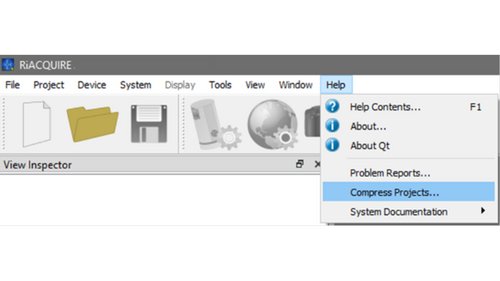
- Start RiACQUIRE, go to Help > Compress Projects… .
- A new window will pop up. Click +, navigate to the projects root directory, and select the .rpp file.
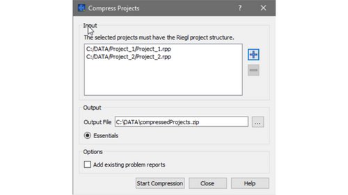
- (Optional) Add additional projects.
- In Output File, change the directory or file name if needed.
- To reduce file size, ensure that Essentials is selected and Add existing problem reports is cleared.
A system documentation file, or (SysDoc), is an encrypted file generated by RiACQUIRE that collects sensor hardware and operational properties.
To create the SysDoc, the entire system must be accessible for RiACQUIRE.
To generate a SysDoc:
- Start the system and create or open a project.
- Initialize the system and wait until all components are fully initialized.
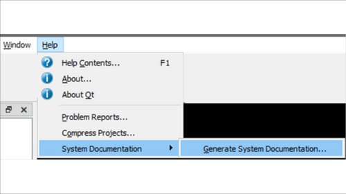
- Go to Help > System documentation > Generate system documentation.
- A new window will open.
(Optional) In the dialog, change the path or file name using ... Next to File Name.
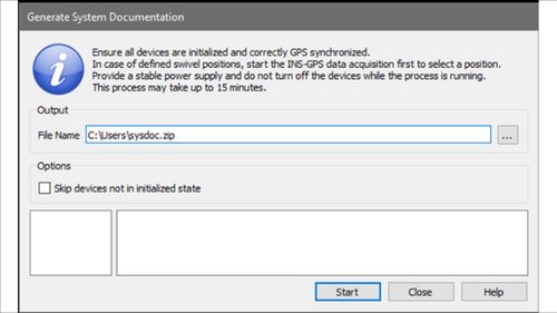
- Click Start.
The process takes approximately 5-10 minutes. The file size is typically larger than 50 MB.
Imagery support logs contain details about image capture processes. This information can be valuable in the event of a camera-related issue.
FILE LOCATIONS
The location of the logs depends on your setup.
Broadly speaking, these fall into the below categories:
- ALS units with an iXController / VQ-IU
- Where the operator works directly on the iXController / VQ-IU
- Where the operator does not work directly on the iXController / VQ-IU
- MLS units
- Using Linux-based CUs/IUs
- Using Windows-based IUs
- Using an external operating PC
Instructions for each of these are provided below the list of files to send.
FILES TO SEND
- RiKINO2.log
- RiTrigSettings.log
- RiTrigUpdate.log
Zip all files in this folder - the result may be quite large.
GETTING THERE
ALS units, working directly on the iXController / VQ-IU
- The logs are located in the following path:
C:\Users\als\Riegl_LMS
ALS units, not working directly on the iXController / VQ-IU
- Open Windows File Explorer and enter: \\192.168.0.78
- If it prompted, use the following credentials:
- Username: als
- Password: als
- Open the log folder.
- Copy all files to your computer.
- Compress the files (Use your favorite tool, e.g. 7-zip)
MLS units - Linux
- Open the home folder (for example, via the Start menu under home/mls, from the Desktop).
- Open the log folder and send its contents through.
MLS units - Windows IU
- Open Windows File Explorer and enter: \\192.168.0.78
- If the connection fails, ensure the unit is powered.
- If prompted, use the following credentials:
- Username: mls
- Password: mls
- Open the log folder, containing the collection of log files.
MLS units - external acquisition PC
- Open Windows File Explorer and navigate to: C:\Users\[user name]\Riegl_LMS
If an issue appears to be occurring between TopoFlight and RiACQUIRE, TopoFlight logs can help identify the cause.
If you experience any general issues with your kinematic RIEGL scanner (VQ-xxx, VUX-xxx, LMS-Qxxx) or notice any unusual behavior while capturing data, collect the support log files using the wizards, depending on the instrument type as listed:
Scanners of the RIEGL V-Line Series
- Run wizard ‘CW_V-Line_Sxxxxxxx_error_analyze’ and provide the result file:
Note: Ensure that the correct scanner IP is entered and that standard port 22 is used
Scanner of the RIEGL LMS-Q Series
- Run wizard ‘LMS-QZXXX_ErrorMemory’ and provide the result file:
Then, follow the steps in question “I need help with my RIEGL scanner or the RIEGL software I am using. What should I do?” in section “Support” to provide them to your local support agent.
RiPROCESS is the RIEGL software package for kinematic LiDAR data processing. In case of an issue, the best way is to provide a RiPROCESS Support.zip file.
A RiPROCESS Support Zip file is an collection of important information and log files about your processing environment, such as installed modules, system resources, and background logs.
To create a RiPROCESS Support.zip file:
- In RiPROCESS, go to ? > Send support request...
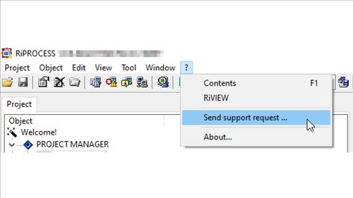
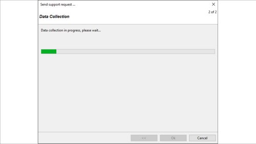
- Click through the resulting dialogue. It will collect certain files and generate a ZIP.
- On the final page, click Support.zip (blue font color) to open the file in Windows File Explorer.
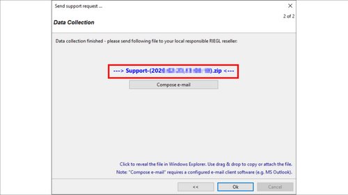
You can then attach this file to your support email chain. Alternatively, click Compose email, to creat a draft email in your available email client software (for example, Microsoft Outlook), and send it to your local RIEGL reseller.
Then, follow the steps in question “I need help with my RIEGL scanner or the RIEGL software I am using. What should I do?” in section “Support” to provide them to your local support agent.
If the RIEGL Support Team requests raw scanner data, provide a minimal example that illustrates the reported issue.
RIEGL Systems and Complete Platforms:
If you are using an RIEGL-integrated system (such as the VQ-1560-, VMX-, VMQ-, VMY-, VMZ-, or VUX-SYS series), provide the following data:
SCANNER RAW DATA
- raw data of the scanner (*.RXP) (for LMS-Q Series *.SDF, compress!)
- post-processed trajectory file (*.POFX, *.POQX)
- RiPROCESS compressed project (link)
- in case of an issue with the data export: GeoSysManager database (*.GSFX + all referenced *.GSB *.GDF) ,
- if used: atmospheric condition file (*.ACL), …
TRAJECTORY RAW DATA
- trajectory raw data (*.LOC.RXP) (*.T04) (*.RAW) (VMX.###) (ALS.###) (VUX-SYS.###) (*.MON.IGS)
- GNSS antenna lever arm information
- base station raw data (RINEX observation file: *.##O)
- base station documentation [base station coordinates + CRS information (EPSG code)]
CUSTOMER-BUILT INTEGRATIONS
If you have integrated a system yourself, provide a minimal example that illustrates the reported issue.
SCANNER RAW DATA AND TRAJECTORY DATA
- raw data of the scanner (*.RXP) (LMS-Q Series *.SDF, compress!)
- post-processed trajectory file ( *.POFX, *.POF, or an ASCII file with timestamp, position (lat, long, alt), attitude (roll, pitch, yaw) wrt. a NED navigation frame)
- RiPROCESS compressed project (link)
- system mounting information
- RIEGL-System-Description File (*.RiSD) or
- RiPROCESS project file (*.RPP) or
- Scanner Mounting Matrix (*.4X4) and Scanner Calibration information (*.CAL) or
- technical drawing of the system setup showing the offsets between the IMU's center of computation and the SOCS
Applanix POSPac is Trimble Applanix’ software for GNSS/INS Direct Georeferencing for INS sensors.
POSPac has its own separate system of support files and information.
WHAT ARE THE BASICS WE WILL NEED FOR YOUR TROUBLESHOOTING?
To best assist with your POSPac inquiry, provide the following:
- Your POSPac license serial number
- A description of the issue
- A POSPac PDF report
You may also be asked to provide:
- Your raw POS data (from 02_INS-GPS_RAW\02_FULL)
- Any base station data you have used
- Your processed POSPac project file and directory
HOW DO I FIND MY POSPAC LICENSE SERIAL?
If you no longer have access to your original license or EID documentation:
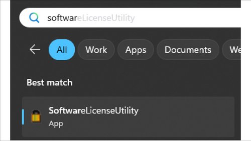
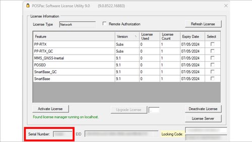
- Open your Software License Utility.
- By default, it is located at: C:\Program Files (x86)\Applanix\SoftwareLicenseUtility
- The license serial number is displayed at the bottom of the tool:
HOW DO I GENERATE A POSPAC PROJECT DIAGNOSTIC REPORT?
With your problematic project open:
- On the Reports tab, click QC Report.
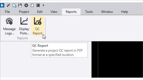
- A new panel will open on the right side of your window.
- Ensure that the report template is set to Diagnostic.
- Take note of where the file is saving (in Report File Name).
- Click Generate at the bottom.
- Attach the generated file to your support request.
If you experience any general issues with your VZ-scanner or notice any unusual behavior while capturing data, collect support logs using the appropriate wizard for your instrument type:
VZ-i Series
- Run wizard ‘CW_VZ-xxxi_Hxxxxxxx_error_analyze’ and provide the result file.
VZ-Series
- Run wizard ‘CW_V-Line_Sxxxxxxx_error_analyze’ and provide the result file.
Then, follow the steps in question “I need help with my RIEGL scanner or the RIEGL software I am using. What should I do?” in section “Support” to provide them to your local support agent.
To receive comprehensive and prompt support from the RIEGL support team, provide the following information for all processing stages:
RiSCAN Support Zip:
- Open RiSCAN PRO and load the problematic project.
- Go to Help > Create Support.zip.
If the RIEGL Support Team requests scanner data, provide a minimal example that illustrates the reported issue.
Provide the following data:
- RiSCAN Support Zip
- Example Project (*.PROJ or *.riproject) where all ScanPos where removed except 1-3 ScanPos illustrating the problem
In such cases, contact your local reseller first. They will contact RIEGL on your behalf and assist you throughout the process.
If you purchased the scanner directly from RIEGL, email us at support@riegl.com.
Always contact your local reseller or RIEGL before sending or dropping off any hardware.
Warranty and guarantee periods depend on factors such as the product, system configuration, destination, and regional regulations. The applicable periods are specified in your quotation. For further details, please contact your RIEGL sales representative or local RIEGL sales partner.
Register on our RIEGL Members Area. Here you will always find our latest software versions.
RIEGL recommends servicing the scanner/system every two years or after 3000 total operating hours, whichever comes first. Once either of these values is reached, the scanner/system automatically displays this message.
If you are interested in having your scanner/system serviced, contact your local reseller.
Manuals for RIEGL scanners/systems can always be found in the manual folder on the scanner's internal memory. To access them, connect to the scanner's Samba share folder via LAN.
In the software, press F1 to open the latest manual.
You can also find PDF versions in the respective installation folders of the software packages.
Available training materials can be found on the RIEGL Members Area.
In general, licenses remain valid even after the end of software maintenance, and you can continue to use the corresponding RIEGL software. However, it is no longer possible to update to newer software versions that are released after the end of maintenance.
To use newer versions, extended software maintenance must be purchased. Contact your local reseller for this.
To find out which software version can be used with expired licenses, take a look at the revision history of the relevant software, which you can find in our Members Area.
Here you will find the release date for each version. The release date must be before the end date of the software maintenance.
The end date of the software maintenance can be found on the license certificate, in LicenseCenter or the LicenseServer Administration Center, or in License Manager (RiACQUIRE, RiACQUIRE Embedded Desktop).
Before installing the latest version of a software package, ensure that you have a valid maintenance contract for the respective package (and the required plug-ins).
No, there are dependencies between the RIEGL software tools that must be taken into account.
Dependencies are listed in the release notes/revision history of the respective tool under ‘Dependencies’.
RIEGL offers the following two main license types:
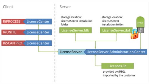
SINGLE INSTANCE FLOATING LICENSE - SIL
- SILs are bound to a certain dongle (only one USB dongle per computer/server is supported).
- SILs require the use of the RIEGL LicenseServer (download via Members Area). RIEGL LicenseServer has to be installed on a computer/server and the RIEGL USB dongle must also be connected to this computer/server.
- For every feature (more information in the questions “Which licenses are required for which software module in kinematic scanning / terrestrial scanning?” in section “Licensing”), a separate SIL license code (license key) is issued, which has to be imported in the RIEGL LicenseServer Administration Center.
- The license server and the workstations running RIEGL software have to operate in the same network.
- Each SIL has a temporal maintenance limit (maintenance period).
SCANNER SERIAL NUMBER LICENSE - SNL
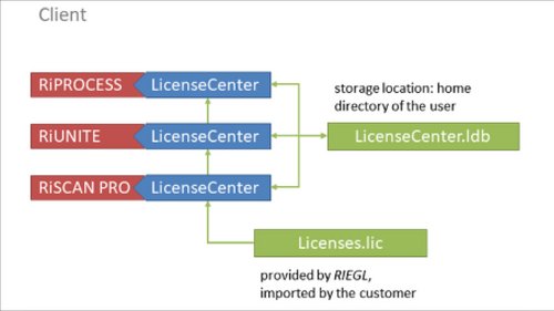
- SNLs for the features listed below (see chapter 1.3 Software features for kinematic scanning) can be issued to the serial number of a specific RIEGL LiDAR scanner. The serial number is encoded in the data stream of each scanner and replaces the dongle.
- New RIEGL LiDAR scanners are already prepared to support this new licensing type. For older scanners a firmware update is required.
- The SNL license code (license key) has to be added to every workstation (and for every user) via the RIEGL LicenseCenter, on which the feature is to be used.
- SNLs allow the use of the associated feature for processing the data of this specific LiDAR scanner (serial number) on a workstation without limitation on the number of instances.
- SNLs can be used in parallel on several workstations.
- Each SNL has a temporal maintenance limit (maintenance period).
WHAT IS A LIGHT LICENSE?
In addition to the two main license types, certain licenses are also available as a special light version, independently of the license type.
- Light Licenses are offered at a reduced price. Only data from the following device types are supported: miniVUX-1UAV, miniVUX-1DL, miniVUX-2UAV, miniVUX-3UAV, VZ-i-Series Terrestrial Scanner
- Light Licenses can be purchased as SIL or as SNL.
- Light Licenses are working in the same way as SILs or SNLs and are thus bound to the serial number of a specific RIEGL LiDAR scanner, or to a RIEGL server USB dongle (only one dongle per workstation / server is supported).
- Light Licenses have a temporal maintenance limit (maintenance period).
We recommend that customers processing data from more than one RIEGL LiDAR instrument on different workstations opt for the Single Instance Floating License(s). These licenses are installed and managed by LicenseServer, which is installed on a single machine acting as a server within a local network. Thus, only one dongle is required, and the number of instance licenses can be increased by ordering more, if needed.
If working with a dongle is not appropriate, the Instrument Serial Number License allows for easy post-processing of all data from a specific instrument for which the customer has purchased a license.
For customers with offices in different locations that do not share a common LAN, RIEGL recommends obtaining a serial number license for each RIEGL LiDAR scanner used for processing data.
If you are unsure which type of licenses (SIL or SNL) you have check you Software License Certificate which was provided to you after purchasing your licenses.
On the first page the license type and the functionality of the purchased licenses are listed. There the information whether the licenses are bound to a certain dongle (SIL/ SIL light) or whether the licenses are bound to the serial number of a RIEGL device can be extracted (see figures below for further understanding). Depending on your license type you have to import your licenses (*.lic file) to either the RIEGL LicenseServer Administration Center (for SIL/SIL light) or to the RIEGL LicenseCenter (for SNL/SNL light).
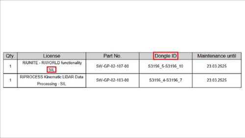
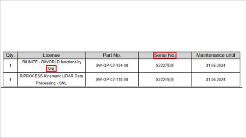
Every purchased software maintenance is valid for a specific time period. The expiry date of the software licenses is listed next to the imported license in either the RIEGL LicenseCenter (for SNL) or the RIEGL LicenseServer Administration Center (for SIL). Note that in case the software maintenance has expired, the user is only entitled to work with the software release versions which were released last prior the expiry date of the software maintenance.
To receive an offer for purchasing/ extending a software maintenance always contact your local reseller.
If you purchased the scanner directly from RIEGL, email us at sales@riegl.com.
Different options are shown below:
SOFTWARE LICENSE CERTIFICATE
When you purchase a license for RIEGL software, you will receive a license certificate. In addition to the license name and keys, the certificate states the end of the maintenance period.
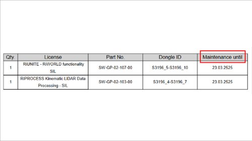
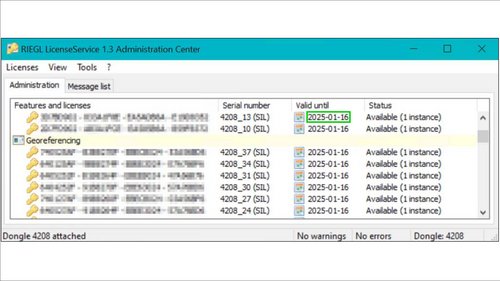
SINGLE INSTANCE FLOATING LICENSES (SIL)
In the RIEGL LicenseServer Administration Center the maintenance date of SIL licenses is displayed.
After the listed ‘Valid until’ date has been reached you are only entitled to work with the corresponding software release version of the RIEGL software suite which were released last prior the expiry date of your software maintenance.
SCANNER SERIAL NUMBER LICENSES (SNL)
In the RIEGL LicenseCenter, under the 'Licenses' tab, you can view the maintenance status of your SNL licenses. If the status next to your license shows ‘Maintenance’ (see the green box in the below screenshot), then your SNL license is valid until the ‘Valid until’ date listed.
However, if the status shows 'Time limit is expired' (see red box in the screenshot below), the software maintenance of your SNL license expired at the mentioned 'Valid until' date. In this case you are only entitled to work with the corresponding software release version of the RIEGL software suite which were released last prior the expiry date of your software maintenance.
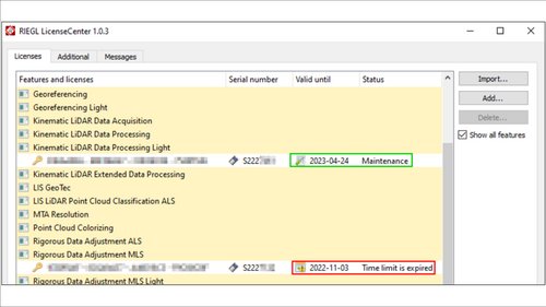
To receive an offer for purchasing/ extending a software maintenance always contact your local reseller.
If you purchased the scanner directly from RIEGL, email us at sales@riegl.com.
RIACAUIRE AND RIACQUIRE EMBEDDED
In RiACQUIRE and RiACQUIRE Embedded Desktop, the maintenance period is displayed in the Until' field in License Manager. You can open License Manager via System > License Manager.
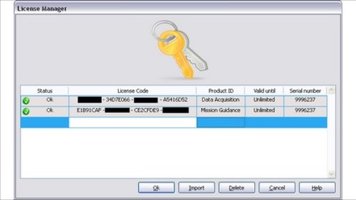
RIACQUIRE EMBEDDED WEB GUI
To view the expiration date of a license, go to More > Licenses and click the respective license:
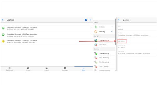
The following is an explanation of the different tools:
RIEGL LICENSESERVER / RIEGL LICENSESERVICE
RIEGL LicenseServer / RIEGL LicenseService allows you to use floating licenses (SIL) for RIEGL software products. All licenses can be stored on a single computer (= license server) available in your local network. The RIEGL LiceneServer / RIEGL LicenseService distributes the licenses through the network.
The RIEGL LicenseServer Administration Center is used to manage the licenses on your server.
RIEGL LicenseService (LicenseService.exe) is a Windows service. To be started and/or stopped, you have to use the Windows Services App (search for Services in the Windows start menu). The LicenseServer.exe executable is a normal Windows application (no Windows service) and can be started on the command line like any other application or via the LicenseServer.exe.
Note: We recommend using the RIEGL LicenseService (Windows service). This way the service is started and operating on Windows startup and no user needs to log on to start it. The LicenseServer executable is included mainly for backward compatibility reasons and may no longer be supported in the future.
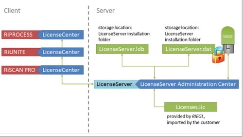
RIEGL LICENSECENTER
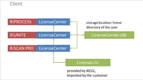
RIEGL LicenseCenter allows you to manage licenses for RIEGL software products. All local licenses are stored in a License database (LicenseCenter.ldb) located in the user’s home directory by default. You can import, add, update and delete license keys stored in the database.
Scanner serial number licenses (SNL) are imported to the RIEGL LicenseCenter > Licenses
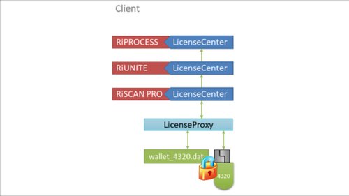
RIEGL LicenseCenter also allows to borrow floating Single Instance Licenses (SIL) from a RIEGL LicenseServer (or RIEGL LicenseService) and store these licenses in a local wallet bound to a connected dongle on this machine. These borrowed licenses can be returned to the server, too.
For more information, see the RIEGL LicenseCenter manual under Borrowing licenses from a LicenseServer.
RIEGL LICENSEPROXY
RIEGL LicenseProxy is a Windows service responsible for borrowing, using, and returning floating instance licenses (SIL).
To borrow licenses from a license server, ensure that RIEGL LicenseProxy is installed and running.
You can start or stop RIEGL LicenseProxy in the Windows Services app (search for Services in the Windows Start menu).
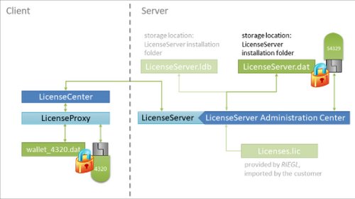
If you use SIL licenses, set up a license server in your network.
Ensure the following:
- The server dongle is permanently attached to the PC acting as the license server.
- Either RIEGL LicenseServer or RIEGL LicenseService is running on that PC.
For more information, see the RIEGL LicenseServer manual.
RIEGL LICENSESERVER
Download the latest release version of the RIEGL LicenseServer from the RIEGL Members Area.
Start RIEGL LicenseServer by running LicenseServe.exe in the installation folder (default: C:\Program Files (x86)\Riegl_LMS\LicenseServer ).
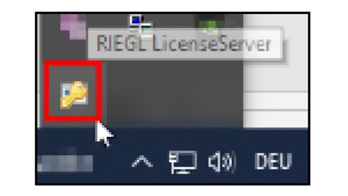
To check if RIEGL LicenseServer is running, open the taskbar menu of your PC and verify that the RIEGL LicenseServer icon is displayed (see figure below).
To stop the RIEGL LicenseServer, right-click the icon and select Shutdown.
RIEGL LICENSESERVICE
If enabled (default), the RIEGL LicenseServer setup automatically registers RIEGL LicenseService in Windows.
You can start or stop RIEGL LicenseService in the Windows Services app (search for Services in the Windows Start menu). Use the Services app to configure, start, and stop the service.
The service appears as RIEGL License Service.
Startup type Automatic indicates that the service starts automatically on system restart.
To start or stop the service manually, right-click the entry and select Start or Stop.

For more information on how to set up the PC acting as RIEGL LicenseServer, see the RIEGL LicenseServer manual, Installation.
Important: Do not run LicenseServer, LicenseService, and LicenseProxy at the same time.
Run LicenseProxy only on a client PC that is not acting as a LicenseServer or LicenseService.
On a server PC, run either LicenseServer or LicenseService.
Import the purchased SIL licenses in RIEGL LicenseServer Administration Center on the PC acting as the license server.
You can open RIEGL LicenseServer Administration Center from the Windows Start menu or by running LicenseServerAdmin.exe from C:\Program Files (x86)\Riegl_LMS\LicenseServer.
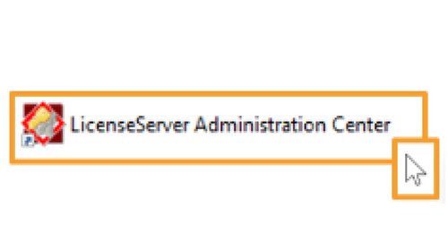
To import the licenses, in RIEGL LicenseServer Administration Center, go to Licenses > Import… and subsequently select the license file (*.lic) that contains your current licenses.
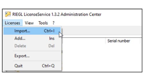
If the processing PC is also the license server, ensure that RIEGL LicenseProxy is deactivated on this PC. This service manages borrowed licenses in a local wallet and is not required if the license server is running on the same machine.
To deactivate RIEGL LicenseProxy on the license server PC:
- Open the Services App (search for 'Services' App in the Windows start menu) on the PC acting as License-Server.
- Double-click RIEGL LicenseProxy.
- Click Stop.
- Set Startup type to Manual so it won't start automatically on next restart.
- Click Ok.
Additionally, verify the following on the license server PC:
- Open RIEGL LicenseCenter.
- Go to the Additional tab.
- If a license server is listed, select it and click Delete (or right-click and select Delete).
- Click Add... and enter:
- Host: 127.0.0.1
- Port: 2066
- Click Save/apply changes now!.
- Open your RIEGL Software and verify that licensed tasks run successfully.
To connect RIEGL LicenseCenter to a LicenseServer or LicenseService:
- In RiPROCESS, go to Tool > License center... And open RIEGL LicenseCenter
- Go to the Additional tab
- Click Auto-detect server(s)
- The IP address or the host name of the PC running RIEGL LicenseServer is displayed. RIEGL recommends using the IP address instead of the host name.
- Click Save/apply changes now!
To test the connection between RIEGL LicenseCenter and the LicenseServer:
- Open RIEGL LicenseCenter
- Go to the Additional tab
- Right-click the name or IP address of the PC listed as LicenseServer
- Click Test (see figure below)
- Verify that the connection is successful.
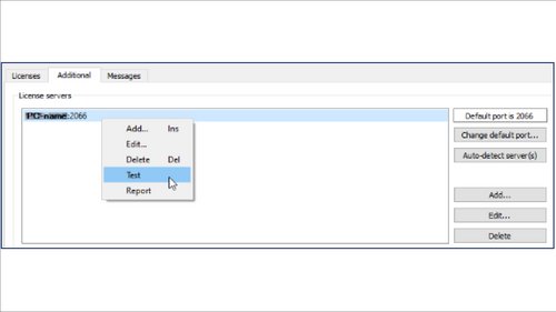
If the connection test fails, add the license server using the local IP address (127.0.0.1):
- In RIEGL LicenseCenter, go to the Additional tab.
- Select the listed License Server, right-click and click Delete
- Click Add..
- Enter the following
- Host: 127.0.0.1
- Port 2066
- Click Save/apply changes now!
- Right-click the newly added license server and click Test
- Verify that the connection is successful.
To verify that licenses from RIEGL LicenseServer Administration Center are retrieved by the RIEGL LicenseCenter:
- Open RIEGL LicenseCenter
- Go to the Additional tab
- Right-click the name or IP address of the PC listed as License server
- Click Report (see figure below)
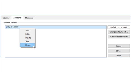
The Messages tab is displayed.
If a license is successfully retrieved from the license server, it is marked as checked (see green box below).
If the licenses are not retrieved, they are marked with warnings such as No licenses were received or Failed to licenses feature (see red box below).
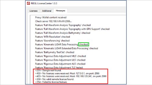
If you cannot retrieve licenses, verify the following:
- The licenses are imported in RIEGL LicenseServer Administration Center.
- If you are working on the license server PC, RIEGL LicenseProxy is deactivated (see chapter 2.3).
On any other PC in your network used for post-processing, ensure that the latest version of RIEGL LicenseCenter is installed. You can download the latest version from the RIEGL Members Area.
It is necessary to add the license server in the RIEGL LicenseCenter:
- Open RIEGL LicenseCenter
- Go to the Additional tab
- Click Auto-detect server(s)
- The IP address or the name of the PC running the License Server is displayed. RIEGL recommends using the IP address instead of the host name.
- Click Save/apply changes now!
Ensure that the latest version of RIEGL LicenseCenter is installed on every post-processing PC. You can download the latest version from the RIEGL Members Area.
Import SNL licenses in RIEGL LicenseCenter on every post-processing PC:
- Open RIEGL LicenseCenter
- Go to the Licenses tab
- Right-click inside the window and click Import licenses
- Select your license file (*.lic) and import your licenses
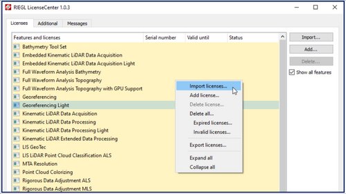
To operate the scanner using acquisition software (for example, RiACQUIRE or RiSCAN PRO) or to access its internal memory, you must establish a LAN connection to the scanner.
RIEGL scanners are delivered with a fixed IP address. The default IP address is set in the scanner at the time of delivery is listed in the user manual.
For Scanner with GUI (for example RIEGL VZ-i-Series), you can check the IP address in the LAN interface settings.
To establish a LAN connection between the scanner and the PC, both devices must be in the same IP address range:
- Connect the LAN cable to the scanner and the PC
- On your computer, go to Control Panel > Network and Internet > Network Connections
- Select the LAN interface in use and open Properties
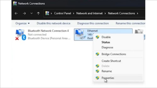
- In Properties, go to Networking > Internet protocol Version 4 (TCP/IPv4)
- Define a IP address in the same range as the IP address of the scanner.
Important: The last three digits of the IP address must differ from the scanner’s IP address.
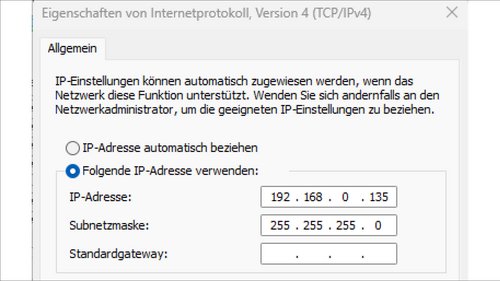
- Click OK
To check the connection, run a PING Test:
- Open the windows command line tool
- Enter ping <IP_of_your_scanner>, see example below
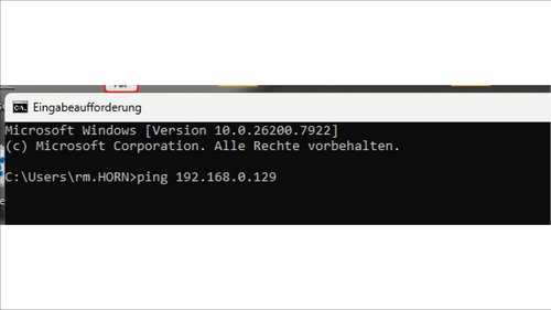
Since Windows 10 and 11, unauthenticated guest logins for SAMBA Server are blocked by default.
To allow unauthenticated guest logins on your PC
- Open Windows Powershell as administrator
- Run the following commands:
- Set-SmbClientConfiguration -EnableInsecureGuestLogons $true -Force
- Set-SmbClientConfiguration -RequireSecuritySignature $false -Force
- Set-SmbServerConfiguration -RequireSecuritySignature $false -Force
By default, all RIEGL VQ-series and VUX-series scanners send a UDP broadcast including SN and IP configuration information.
RIEGL provides a useful tool called RiWATCH located in the RIEGL Members Area.
RiWATCH receives broadcasts from RIEGL scanners and displays the IP addresses of all RIEGL scanners found in your local network. This is useful if you do not know your scanner's IP address or want to check which RIEGL instruments are currently accessible.
There are several reasons why RIEGL has created a wizard for your device. The most common ones are:
- to collect log files and the error memory logs on the device;
- to change device parameters (such as the internal calibration parameters);
- to perform device updates (e.g. firmware updates).
Before running a wizard, please ensure that you have an adequate power supply with sufficient runtime. Please note that runtime varies depending on the type of wizard; some (e.g. firmware updates) can take over 90 minutes to complete.
Required equipment:
- Windows PC;
- LAN cable to connect the device to the PC;
- Adequate power supply for the device.
To run a RIEGL wizard, please follow these steps:
- Download the wizard onto your PC.
- Establish a LAN connection between the scanner and the PC. (Further details can be found in question “How can I establish a connection between my scanner and my PC?” in section “Scanner (Connecting to Scanner, IP, ..)"
- Start the wizard, enter the scanner's IP address in the relevant field and click 'Proceed'.
- A .zip file will then be generated next to the .exe file. Please send this file to the person or organization that provided the wizard to you.
RiPROCESS uses the official list of leap seconds to export timestamps to GPS/UTC. The list is typically valid until the end of June or December. Therefore, the file must be updated regularly.
The easiest way to update the file is to use RiPROCESS Leap Seconds Update, available in the RIEGL Members Area.
You can also update the file manually:
- Download the latest leap-seconds.list file from: https://hpiers.obspm.fr/iers/bul/bulc/ntp/leap-seconds.list
- Replace the exisiting leap-seconds.list file in:
- the RiPROCESS installation folder (root directory)
- PLUGINS > Export subfolder
Restart RiPROCESS for the changes to take effect.
Sometimes, individual elements of the RiPROCESS are no longer visible in their usual locations. One possible reason is that they have been undocked and moved outside of the visible area.
As a first step, connect an external monitor to check whether the missing windows or elements appear there.
You can also reset the RiPROCESS user interface completely. Note that this will cause you to lose all your user settings.
The “RiPROCESS.ini” file stores RiPROCESS's personalized settings such as toolbars and window size/position, etc.. By default, it is located at:
C:\Users\<username>\AppData\Local\VirtualStore\Program Files (x86)\Riegl_LMS\RiPROCESS.
Navigate to this path and perform the following steps:
- Close RiPROCESS.
- Delete RiPROCESS.ini file
- Reopen RiPROCESS and verify that the View Inspector is displayed correctly.
This behavior may indicate a broken RiPROCESS project file (*.rpp).
To restore the project:
- Close RiPROCESS.
- Open the project folder.
- Rename project.rpp to project_old.rpp.
- Rename project.bak to project.rpp.
- Reopen the project.
If data was acquired using RiACQUIRE or RiACQUIRE Embedded, a backup file is also available in the 08_RECEIVED folder.
This file reflects the exact state of the project when it was last closed in RiACQUIRE.