

TERRESTRIAL LASER SCANNING
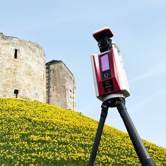
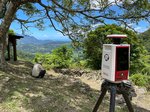
RIEGL VZ-600i
RIEGL‘s latest generation of professional Terrestrial Laser Scanners stands out with extreme versatility, high productivity, ultimate performance and additional mobility – providing an excellent return on investment!

Extremely Versatile High Performance 3D Terrestrial Laser Scanner
The RIEGL VZ-600i offers a broad range capability from 0.5 m up to 1000 m and is suitable for indoor and outdoor 3D mapping applications. 3D position accuracy of 3 mm, less than 30 sec scan time for high-resolution scans with 6 mm point spacing at 10 m, enabling more than 60 scan positions/hour with real-time registration, weight less than 6 kg (13 lbs), 2.2 MHZ PRR, three internal cameras & GNSS integrated, and also prepared for mobile mapping applications – these key features will speed up your workflow in indoor and outdoor applications.
For operating the scanner and for data processing, RIEGL offers the well established software package RiSCAN PRO. Different license levels and plugin module licenses allow an adaption to the user specific requirements.
Main Features
- broad range capability (0.5 m up to 1000 m)
- 5 sec scan time for low resolution overview scans
- 30 sec scan time for 6 mm resolution @ 10 m distance
- 60 scan positions per hour (with image acquisition)
- 3D position accuracy up to 3 mm @ 50 m
- high laser pulse repetition rate of up to 2.2 MHz
- scan speed up to 420 lines/sec
- eye safe operation at Laser Class 1
- precise real-time onboard registration
- internal cameras (offering optional on-board face detection and automatic facial blurring in real-time before image storage)
- internal GNSS receiver / external RIEGL GNSS RTK receiver (optional)
- optional external system camera or panorama camera
- weight 6 kg / 13 lbs
- prepared for mobile use


Main Applications
- As-Built Surveying
- Architecture & Facade Measurements
- Civil Engineering
- Building Information Modeling (BIM)
- City Modeling
- Forensics & Crash Scene Investigation
- Emergency Management Planning
- Archeology and Cultural Heritage Documentation
- Tunnel Surveying
- Forestry
- Research
Technical Data Overview
| Laser Pulse Repetition Rate PRR (peak) | 2200 kHz | 1200 kHz | 600 kHz | 140 kHz |
|---|---|---|---|---|
| Max. Measuring Range (p ≥ 90%) | 220 m | 320 m | 420 m | 1000 m |
| Max. Measuring Range (p ≥ 20%) | 100 m | 150 m | 200 m | 450 m |
| Minimum Range | 0.5 m | 0.5 m | 0.5 m | 1 m |
| Max. Number of Targets per Pulse | 5 | 10 | 15 | 15 |
| 3D Position Accuracy | 3 mm @ 50 m, 5 mm @ 100 m | 3 mm @ 50 m, 5 mm @ 100 m | 3 mm @ 50 m, 5 mm @ 100 m | 3 mm @ 50 m, 5 mm @ 100 m |

Software for RIEGL VZ-600i
We complement our high-performance hardware with innovative software packages to create powerful solutions for demanding applications. The RIEGL software packages are exclusively bundled with the appropriate RIEGL laser scanners and laser scanning systems. For this RIEGL product we provide:
Explore some selected pointcloud samples.
For use with the RIEGL VZ-600i, special plugins, apps, and libaries are provided :
- RiPANO
to explore your project and to extract plots in your browser - RIEGL LIS GeoTec Plugin
for geotechnical analysis of scanned rock surfaces - RIEGL LIS TreeAnalyzer Plugin
for the automatic extraction of various individual tree parameters in forestry - RIEGL VZ-i Series App
to control your RIEGL VZ-i Series laser scanner system remotely - RIEGL VZ-i Monitoring Apps
for real-time analysis and data processing in diverse monitoring and mining applications - RIEGL VZ-i Series Kinematic App
to use your terrestrial laser scanner for kinematic data acquisition - RiVLib
for developing custom software - RDBLib
for reading and writing various types of data - VZ-i ROS Driver
designed to help developers build robot applications
Download Area & Further Information
RIEGL VZ-600i
Case Studies


RIEGL VZ-600i
Gallery
.")


")


.")
.")


EXPLORE
Video Collection
RIEGL VZ-600i
News & Insights


CONTACT
Get in touch.
Our team is happy to answer any questions you may have about RIEGL products and solutions. For technical support or general inquiries, please use the contact details below.
Technical Support:
info@riegl.cn
General Questions:
info@riegl.cn
(+86) 186 1222 7749
Looking for more information?
Send us your request using the product inquiry form.