
UAV-BASED LASER SCANNING
RIEGL miniVUX-4UAV
NEW
The extremely lightweight RIEGL miniVUX-4UAV acquires data at a laser pulse repetition rate of up to 400 kHz. With a field of view up to 360°, it enables up to 200,000 measurements on the ground at a scan speed of up to 150 scans/sec. A more tightly focused laser beam ensures maximum spatial resolution with improved accuracy. Thanks to these features, the sensor is ideal for reliable object detection in complex environments.
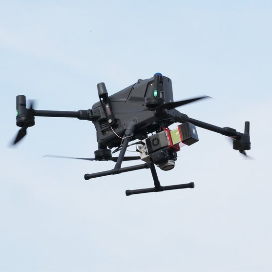

LiDAR Sensor for UAV-based Laser Scanning
The RIEGL miniVUX-4UAV is an extremely lightweight airborne laser scanner, designed specifically for integration with UAS/UAV/RPAS.
The sensor offers a selectable laser pulse repetition rate (PRR) of 100 kHz, 200 kHz, 300 kHz, and 400 kHz. With 400 kHz PRR, it provides up to 133,333 measurements per second at 120° FoV and thus, a dense point pattern on the ground for UAV-based applications that require the acquisition of small objects.
Together with an improved laser beam divergence and accuracy specifications of 12 mm accuracy and 8 mm precision, it delivers dense point patterns and highly detailed data for demanding UAV-based applications.
In addition to the stand-alone version of the miniVUX-4UAV, RIEGL also offers system solutions with integrated camera and IMU/GNSS systems, e.g. with RIEGL RiLOC-E25or RiLOC-F.
RIEGL'S PROPRIETARY IMU/GNSS SOLUTION RILOC
RIEGL RiLOC-E25 / RiLOC-F
For providing a fully integrated miniVUX-SYS solution for UAV-based data acquisition, the RIEGL miniVUX-4UAV is available with a subsystem for localization and orientation (Localization/Orientation Component), which includes a Micro Electro Mechanical System (MEMS) Inertial Measurement Unit (IMU), a GNSS unit, and appropriate software. All components are included in a compact and lightweight housing, that is directly attached to the rear panel of the sensor.
RIEGL’s proprietary IMU/GNSS solution RiLOC for the miniVUX-4UAV is available as RiLOC-E25, a cost-efficient version for small scale applications, and as RiLOC-F, a high-precision version for maximum accuracy in the georeferencing of the high-precision LiDAR data.
Main Features
- 100 kHz / 200 kHz / 300 kHz / 400 kHz laser PRR selectable
- measurement rate up to 200,000 measurements/sec
- scan speed up to 150 scans/sec
- very compact & lightweight (1.55 kg / 3.4 lbs)
- up to 360° field-of-view
- robust aluminum housing, ready to be mounted on multi-rotor, rotary-wing, and fixed-wing UAVs
- makes use of RIEGL’s unique echo signal digitization and online waveform processing
- multiple target capability – up to 5 target echoes per laser shot
- mechanical and electrical interface for IMU mounting
- RIEGL RiLOC IMU/GNSS system solutions available
- exceptionally well suited to measure in snowy and icy terrains
- user-friendly, application- and installation-oriented solutions for integration

Main Applications
- Agriculture & Forestry
- Archeology and Cultural Heritage Documentation
- Construction-Site Monitoring
- Topographic & Corridor Mapping
- Snow, Glacier and Environmental Mapping
- Slope, Landslide & Erosion Monitoring
Technical Data Overview
| Laser Pulse Repetition Rate PRR | 100 kHz / 200 kHz | 200 kHz (reduced power), 360° FOV | 300 kHz / 400 kHz |
|---|---|---|---|
| Max. Measuring Range (p ≥ 20%) | 170 m | 150 m | 170 m |
| Max. Measuring Range (p ≥ 60%) | 290 m | 250 m | 290 m |
| Max. Measuring Range (p ≥ 80%) | 330 m | 280 m | 330 m |
| Max. Number of Targets per Pulse | 5 | 5 | 5 |
| Minimum Range | 2 m | 2 m | 2 m |
| Accuracy / Precision | 12 mm / 8 mm | 12 mm / 8 mm | 12 mm / 8 mm |

Software for RIEGL miniVUX-4UAV
We complement our high-performance hardware with innovative software packages to create powerful solutions for demanding applications. The RIEGL software packages are exclusively bundled with the appropriate RIEGL laser scanners and laser scanning systems. For this RIEGL product we provide:
These RIEGL software packages are complemented by special libraries (RiVLib, RDBLib) and plugins (RiMAP Plugin for ArcGIS).
Explore some selected pointcloud samples.
RIEGL miniVUX-4UAV
News & Insights


CONTACT
Get in touch.
Our team is happy to answer any questions you may have about RIEGL products and solutions. For technical support or general inquiries, please use the contact details below.
Technical Support:
click here
General Questions:
sales@riegl.co.uk
+44 (0) 1904 217785
Looking for more information?
Send us your request using the product inquiry form.