TECHNOLOGY, CASE STUDY
Enhancing Maritime Safety with Real-Time Air Draft Measurements using LiDAR Technology
This paper describes the development and installation of a system capable of scanning vessels in transit and advising their measured air draft to VTS (Vessel Traffic Services) before the vessel reaches the critical navigation point, namely the West Gate Bridge in Melbourne, Australia.

The Challenge
The safe passage of ships under bridges or other overhead obstructions requires precise and reliable information about their actual height (air draft). Air draft is defined as the vertical distance from the waterline to the highest fixed point on a vessel – a really critical factor as even small inaccuracies can pose significant risks in height-restricted waterways.
Ports Victoria identified a need to improve safety around air draft limited passages under the West Gate Bridge in Melbourne. The existing process relied on self-declared air drafts submitted by ships and their agents – with no possibility of verification before reaching the critical point.
The Solution
OMC International delivered a new, world-first solution leveraging advanced LiDAR technology to measure the air draft of moving vessels in real time, delivering an unprecedented level of accuracy and timeliness to ensure
- early detection of potential exceedances
- timely corrective action before reaching critical infrastructure
LiDAR technology was selected due to
- high spatial accuracy and resolution, allowing identification of thin features like antennas
- consistent performance across lighting conditions, including night time
- tolerance to fog and rain
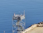
At the core of the system is the powerful RIEGL VZ-2000i, whose high range, resolution, and measurement speed ensure reliable performance even in complex operational environments. It can be controlled via program code, features both 2D and 3D scan modes, and offers built-in computing power for processing point cloud data.
The LiDAR device is housed inside an actively cooled protective enclosure called a Syperion ArmourCase.
From Manual to Automated
Unlike traditional approaches that rely on manually reported values—often affected by miscalculations, changing cargo loads, or structural modifications—this automated system eliminates uncertainty. It continuously captures and processes data without human intervention, delivering consistent, objective, and highly accurate results.
This paper explores the system’s design and workflow in detail:
- LiDAR (Light Detection and Ranging) operation and configuration
- hardware components
- data processing methodologies
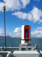
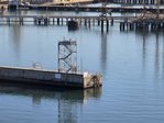
The project was carried out in the Port of Melbourne, Australia, specifically in the area of the Yarra River area around the West Gate Bridge, where on average six vessels with over 100 m length transit each day. The LiDAR installations have been positioned at Breakwater Pier and South Wharf. Key challenges encountered during implementation, such as wildlife interference and the influence of ship material properties on measurement accuracy, are outlined in the paper.
Find out more on this new benchmark for monitoring and managing vessel clearance in modern port environments in this research paper, that was presented at the Australasian Coasts & Ports 2025 Conference and is available here.