CASE STUDY
Ribblehead Viaduct's Heritage Protected Using Low-Impact 3D Railway Track Surveying
Discover how a terrestrial LiDAR and railway drone survey supported the heritage of the Ribblehead Viaduct

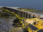
RIEGL’s VZ-400 Series – a terrestrial LiDAR scanning system - has been integral in helping Network Rail document Ribblehead Viaduct and produce a 3D model of the structure to help assess its condition.
The terrestrial laser scanning (TLS) system was used alongside drone photography to support the heritage documentation of the Viaduct for Network Rail.
Railway Track Surveying: How It Began
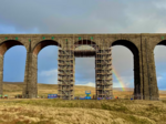
In 2020, Network Rail assessed the Ribblehead Viaduct as part of routine maintenance planning. Given the historical significance of the viaduct - and its classification as a Grade II Listed Victorian Viaduct - the railway survey required a low-impact approach. The idea was to avoid disruption to the architecture and reduce the risk of damage.
Network Rail contracted Commendium, a UK-based 3D surveying specialist known for detailed, low-impact geospatial surveys, to do a forensic scan of the Ribblehead Viaduct.
RIEGL’s VZ Series has ranging capabilities, advanced data acquisition, and novel registration techniques that ensured Commendium’s rail survey produced accurate datasets. The company used a combination of drone photography, RIEGL’s TLS, and remote sensing techniques to create the detailed 3D model of the structure.
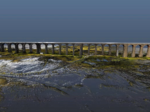
The datasets were subsequently used to assess the structural condition of the Ribblehead Viaduct and to support the planning and prioritisation of necessary maintenance works. By using the ‘reflectance mode’ point colouring in the RIEGL system, the team was able to identify structural issues—specifically damp areas—which then informed targeted repair strategies. This approach ensured that the required interventions were both effective and minimally invasive, helping to preserve the historical integrity of the viaduct’s railway infrastructure.
How RIEGL’s Laser Scanning Technology Streamlined a Rail Survey
The efficiency of the laser scanning is thanks to the unique capabilities of waveform LiDAR and the RIEGL terrestrial laser scanner, which provided:
- Rapid data capture: Data was captured quickly and precisely over long ranges to poorer target types
- Ease of processing: Online waveform analysis and advanced point cloud registration techniques reduced the post-processing overhead, seamlessly registering approximately 100 scan positions in all
- Data interrogation: RiSCAN PRO software provided a robust point cloud registration across the entire survey area, critical for analysis of geometrical dimensions and structural monitoring
- Calibrated reflectance output: Range-independent surface reflectivity enabled an accurate distinction between surface types such as vegetation and ground and variations of similar surfaces, helping to identify biological weathering and water pooling.
Survey Results for Ribblehead Viaduct
Commendium’s LiDAR survey of the Ribblehead Viaduct ultimately revealed damp areas across the structure’s stonework, indicating early signs of deterioration.
Using the RIEGL scanner’s calibrated reflectance mode, the team analysed the reflectivity of the stone surfaces. This allowed for accurate comparisons of localised material properties, aiding in the identification of areas requiring attention.
Following a detailed analysis of the scan, engineers found numerous damp patches across the viaduct, suggesting that the main priority to address was its drainage.
Left alone, these damp zones could have led to mortar erosion and freeze-thaw damage, speeding up the deterioration of the historic stonework. Acting promptly, engineers:
- Repaired brickwork
- Removed vegetation
- Remedied plant-induced damages
- Upgraded drainage across the viaduct’s 24 arches
- Repainted metal components
- Repaired exposed pipework
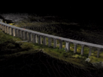
Capturing heritage imagery
The RIEGL system was used in conjunction with a drone and camera payload. While LiDAR scanning and RIEGL terrestrial scanning equipment helped identify hidden structural issues via waveform analysis, drone technology was used to capture heritage photography.
Drones, high resolution imagery and RIEGL LiDAR systems are often used together when surveying railway networks. This combination provides highly accurate scanning data that can serve as the primary 3D model onto which photographic imagery can be overlaid. Drone technology enables non-intrusive data capture in hard-to-reach areas, making it a valuable complement to static scanning.
The data can be reconstructed into high-resolution, highly accurate surface images to provide dimensional accuracy, create depth maps or elevation profiles, and reveal defects.
Other use cases for RIEGL scanner technology in general rail track surveys include: assessing railway embankments beneath tree canopies to monitor for erosion or slippage; analysing ballast profiles; managing vegetation, including identifying encroachment and detecting Dead, Dying, or Diseased (DDD) trees; and monitoring Overhead Line Equipment (OLE), particularly for height and stagger extraction.
Read more about Network Rail’s laser and drone-assisted survey and watch a short video showing the laser scan here.