NEWS, CASE STUDY, PRESS
RIEGL VZ-600i Breaking New Ground in Waterway Monitoring: Vienna Danube Canal and the River Thames
Monitoring riverbanks and bridge undersides is vital for public safety and environmental preservation, as Dave Foster and Bernhard Groiss from RIEGL and Ulrich Zangerl from viadonau explain in a recent GeoConnexion interview.

The Danube Project: Vienna’s Canal Survey
RIEGL’s VZ-600i hybrid terrestrial laser scanner is setting new standards in waterway surveying. The journey began on Vienna’s Danube Canal, where RIEGL partnered with viadonau - a Viennese business charged with ensuring the smooth operation of the Danube waterway - to tackle one of the most challenging environments for surveyors: narrow waterways with limited GNSS coverage. Mounted on a boat, the scanner delivered centimeter-level accuracy even under bridges and in GNSS-denied zones.
The final result? A 3D dataset with a spatial resolution of just 1.5 centimeters and a positional accuracy of 2 to 3 centimeters, which is a level of detail that far exceeds what’s typically achievable in such environments.
The narrowness of the canal, the amount of traffic, and the limited access from the banks make it incredibly difficult to conduct thorough terrestrial surveys. We needed a flexible, high-resolution solution that could operate effectively from a vessel.
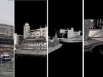
The Thames Project: London’s Heritage Bridges
Building on the success of the Danube project, the technology was then applied to London’s River Thames. Early results are already revealing valuable insights: previously inaccessible areas beneath heritage bridges have been captured in high detail, enabling structural engineers to assess aging masonry and detect early signs of stress or erosion. Data from an earlier survey conducted with the RIEGL VMX-2HA mobile mapping system was integrated to produce a coherent point cloud. By combining surface-level data with measurements taken from beneath the bridges, engineers can now study each structure in unprecedented detail.
We were excited to get the opportunity to scan from a boat on the River Thames. We utilized the VZ-600i to carry out this survey – and this type of project shows the versatility of the VZ-600i which all adds to an already highly productive tool. Part of the survey question was to see what could be achieved within one hour and subsequently to then examine quality of the data. Ideally, we would have been able to add survey control to the project, to bolster the RTK GNSS positioning and monitor the overall project accuracy. The results were excellent, and with Bernhard Groiss collaborating alongside me, he expressed full confidence in the quality of the data we were capturing. His experience from the Danube project was extremely beneficial. The survey was conducted solely in radar mode—a less common approach compared to the combined use of radar and profile modes—yet it delivered a remarkable glimpse into the capabilities of the RIEGL VZ-600i.

Why this matters:
- Hybrid flexibility: Seamless transition between static and kinematic modes.
- Accuracy in motion: GNSS/IMU integration ensures centimeter-level precision despite vessel dynamics.
- Actionable insights: High-fidelity datasets empower engineers, hydrologists, and planners to safeguard infrastructure and ecosystems.
- Future-ready surveying: Establishes new benchmarks for sustainable waterway management worldwide.
There are systems on the market that can be expected to deliver similar results; however, no other system allows you to move directly from a static, high-precision surveying project to mounting on a tripod aboard a boat and continuing to scan seamlessly as you travel down a river, pass under bridges, and capture areas that otherwise could never be surveyed in such detail. With the RIEGL VZ-600i, this becomes possible. It is truly spectacular, and it deserves to be showcased in a setting as iconic as the Thames, with all its famous landmarks.
At RIEGL, we remain committed to pushing the boundaries of geospatial technology, making the invisible visible and enabling smarter decisions for the future of our rivers and waterways.
Read the full article on GeoConnexion: Breaking new ground in river monitoring | GeoConnexion