
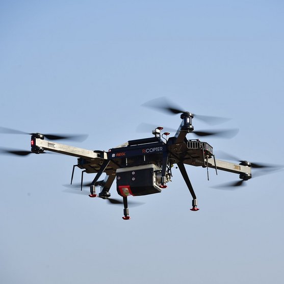
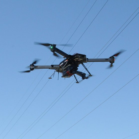
UAV-BASED LASER SCANNING
RIEGL VUX-24024
The RIEGL VUX-24024 is the new version of the proven RIEGL VUX-240, offering higher pulse repetition rates and faster scanning speed for further increased field performance and workflow efficiency. The sophisticated design enables integration with UAS/UAV/RPAS and adequate crewed aero planes or helicopters.

WITH ONLINE WAVEFORM PROCESSING
Lightweight Airborne Laser Scanner
With its wide field of view of 75 degrees and an extremely fast data acquisition rate of up to 2.4 MHz, the instrument is perfectly suited for high point density applications.
A continuously rotating polygon mirror wheel enables scan speeds of up to 600 lines per second, for efficiently covering large areas when operated from fast UAVs or aircraft.
The VUX-24024 makes use of RIEGL's unique Waveform-LiDAR technology, allowing echo digitization and online waveform processing. Multi-target resolution is the basis for penetrating even dense foliage.
The scanner provides an internal data storage capacity of 2 TByte and is equipped with interfaces for an external IMU/GNSS system as well as to control up to four external cameras.
Main Features
- laser pulse repetition rate up to 2.4 MHz
- measurement rate up to 2,000,000 meas./sec
- scan speed up to 600 lines/second
- operating flight altitude up to 1,430m / 4,700 ft
- Field of View up to 75°
- perfectly linear and parallel scan lines
- cutting edge RIEGL technology providing: echo signal digitization, multiple target capability, online waveform processing, multiple-time-around processing
- compact & lightweight
- easly mountable to unmanned platforms (UAVs) and to helicopters, gyrocopters, and other crewed aircraft
- mechanical and electrical interface for IMU/GNSS integration (optional)
- interfaces for up to 4 optional cameras
- scan data storage on internal 2 TByte SSD Memory
- removeable CFAST® memory card
Main Applications
- Corridor Mapping: Power Line, Railway Track and Pipeline Inspection
- Topography in Open-Cast Mining
- Surveying of Urban Environments
- Archeology and Cultural Heritage Documentation
- Agriculture & Forestry
Technical Data Overview
| Laser Pulse Repetition Rate PRR | 300 kHz | 600 kHz | 1200 kHz | 1800 kHz | 2400 kHz |
|---|---|---|---|---|---|
| Max. Measuring Range (p ≥ 20%) | 1200 m | 880 m | 640 m | 530 m | 460 m |
| Max. Measuring Range (p ≥ 60%) | 1940 m | 1440 m | 1060 m | 880 m | 770 m |
| Max. Measuring Range (p ≥ 80%) | 2180 m | 1630 m | 1200 m | 1000 m | 880 m |
| Max. Number of Targets per Pulse | 30 | 24 | 11 | 7 | 5 |
| Minimum Range | 5 m | 5 m | 5 m | 5 m | 5 m |
| Accuracy / Precision | 20 mm / 15 mm | 20 mm / 15 mm | 20 mm / 15 mm | 20 mm / 15 mm | 20 mm / 15 mm |


Software for RIEGL VUX-24024
We complement our high-performance hardware with innovative software packages to create powerful solutions for demanding applications. The RIEGL software packages are exclusively bundled with the appropriate RIEGL laser scanners and laser scanning systems. For this RIEGL product we provide:
These RIEGL software packages are complemented by special libraries (RiVLib, RDBLib) and plugins (RiMAP Plugin for ArcGIS).
Explore some selected pointcloud samples.


RIEGL VUX-24024
News & Insights


CONTACT
Get in touch.
Our team is happy to answer any questions you may have about RIEGL products and solutions. For technical support or general inquiries, please use the contact details below.
Technical Support:
support@riegl.com
General Questions:
office@riegl.com
+43 2982 4211
Looking for more information?
Send us your request using the product inquiry form.