
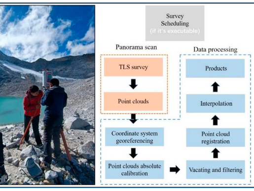
TERRESTRIAL LASER SCANNING
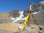
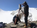
RIEGL VZ-6000
This 3D VZ-Line Laser Scanner offers superior and unrivaled long range reflectorless measurement performance of more than 6,000 m.

WITH ONLINE WAVEFORM PROCESSING
3D Ultra Long Range Terrestrial Laser Scanner
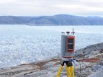
RIEGL's unique V-Line technology is based on echo digitization and online waveform processing, which means that the VZ-6000 operates even in poor visibility and demanding multi target situations caused by dust, haze, rain, snow. Due to its laser wavelength the instrument is exceptionally well-suited for measuring snowy and icy terrain.
For operating the scanner and for data processing, RIEGL offers the well established software package RiSCAN PRO. Different license levels and plugin module licenses allow an adaption to the user specific requirements
Main Features
- Better than 6,000 m measurement range
- exceptionally well suited for measuring snowy and icy terrain
- Wide field of view, 60° x 360°
- High speed data acquisition up to 222,000 meas./sec
- High accuracy, high precision ranging based on echo digitization and online waveform processing
- Multiple target capability
- Multiple time around processing
- Optional waveform data output
- Built-in calibrated digital camera
- On-board inclination sensors
- Integrated L1 GNSS receiver with antenna
- Integrated compass
- Built-in SSD drive storage
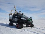
- Compact and rugged design
- Advanced camera options

Main Applications
- Glacier & Snowfield Mapping
- Topography & Mining
- Monitoring
- Civil Engineering
- Archeology & Cultural Heritage
Technical Data Overview
| Laser Pulse Repetition Rate PRR (peak) | 30 kHz | 50 kHz | 150 kHz | 300 kHz |
|---|---|---|---|---|
| Max. Measuring Range (p ≥ 90%) | 6000 m | 6000 m | 4200 m | 3300 m |
| Max. Measuring Range (p ≥ 20%) | 3600 m | 3600 m | 2400 m | 1800 m |
| Minimum Range | 5 m | 5 m | 5 m | 5 m |
| Max. Number of Targets per Pulse | 15 | 15 | 10 | 9 |


Software for RIEGL VZ-6000
We complement our high-performance hardware with innovative software packages to create powerful solutions for demanding applications. The RIEGL software packages are exclusively bundled with the appropriate RIEGL laser scanners and laser scanning systems. For this RIEGL product we provide:
Explore some selected pointcloud samples.
For use with the RIEGL VZ-6000, special plugins, apps, and libaries are provided :
- RiPANO
to explore your project and to extract plots in your browser - RIEGL LIS GeoTec Plugin
for geotechnical analysis of scanned rock surfaces - RIEGL VZ-i Series App
to control your RIEGL VZ-i Series laser scanner system remotely - RIEGL VZ-i Monitoring Apps
for real-time analysis and data processing in diverse monitoring and mining applications - RiVLib
for developing custom software - RDBLib
for reading and writing various types of data
RIEGL VZ-6000
Case Studies


RIEGL VZ-6000
Gallery


CONTACT
Get in touch.
All you need to know about our products or any other RIEGL solution – our Sales Team is taking your questions: vertrieb@riegl-de.com
For technical support please click here.