NEWS, PRESS
Innovation in Every Pulse: RIEGL’s New LiDAR Technologies
Introducing the latest advancements unveiled at INTERGEO Frankfurt 2025 — engineered for precision, built for performance
At INTERGEO Frankfurt 2025, RIEGL once again presents a broad range of innovations for the surveying industry. Powered by cutting-edge Ultimate LiDAR™ Technology, RIEGL’s latest breakthroughs deliver unmatched performance, precision, and versatility – setting new benchmarks in 3D data capture.
Explore the highlights below and learn how you can benefit from RIEGL’s latest developments for your business!
RIEGL INTERGEO NEWS 2025
TERRESTRIAL LASER SCANNING
The RIEGL VZ-6000i-26:

Ultra Long-Range Performance. Optimized for Snow and Ice Applications.
With unmatched long range scanning performance of up to 6000 meters, RIEGL‘s latest generation of long-range professional laser scanners enhances productivity, ensures reliable performance, and offers extreme versatility along with advanced connectivity options. These features make it ideal for large-scale snow and ice applications.
Its powerful hardware, innovative software packages, specialized tools, and intuitive apps streamline your workflow by enabling data acquisition, processing, and analysis with a single click.
Watch this brand new video to experience the power of the RIEGL VZ-6000i-26 and explore some impressive sample data from a massive glacier-covered mountain range, captured from just five scanning positions.
More info: https://www.riegl.com/vz-6000i-26/
TERRESTRIAL LASER SCANNING
The RIEGL VZ-1200i:

Expanding the VZ-i Series with High-Speed, Long Range, and Maximum Efficiency
RIEGL presents a new, powerful member of its well-proven product line of professional terrestrial laser scanners, the RIEGL VZ-1200i. The system was developed specifically for users who need a longer range without sacrificing the speed, precision, and reliability of the RIEGL VZ-i series.
The extremely fast and 6 kg lightweight laser scanner expands the portfolio with greater range and mobility, offering maximum versatility, productivity, and performance for demanding applications. It complements existing solutions rather than replacing them, giving professionals additional flexibility in their daily work.
The RIEGL VZ-1200i is a Class 1 eye-safe laser scanner that combines exceptional range with very high scanning speed. A high-resolution panoramic scan is performed in just 25 seconds in the 2.2 MHz measurement program, reaching distances of up to 450 m. In the 300 kHz measurement program, ranges of up to 1800 m are possible.
The ability to perform kinematic data capture further increases its versatility: Like the other VZ-i Series Laser Scanners, you can use the VZ-1200i either in static mode – with tripod offset approximately every 60 seconds (6 mm resolution at 10 m, including simultaneous photo capture)–or in kinematic mode on mobile platforms with RTK-GNSS accuracy.
That’s true versatility – for a broad range of applications, especially when you need to combine static and kinematic data acquisition, long range coverage, and highly detailed data in one mission.
More info: https://www.riegl.com/vz-1200i/
AIRBORNE LASER SCANNING
The RIEGL VQ-1060

Revolutionizing Corridor Mapping for the Utility Industry
RIEGL‘s VQ-1060, a cutting-edge integrated aerial mapping solution designed specifically for powerline and corridor applications, seamlessly integrates multi-directional 3D laser scanning, forward and aft oblique RGB imagery, and nadir multispectral imaging into a single, streamlined platform.
Whether you’re conducting utility asset inspections, vegetation encroachment analysis, or corridor planning, the VQ-1060 provides ultra-high-resolution data with unmatched efficiency – all from a single instrument.
Precision Meets Performance*
- Delivers ~70 points/m² from 1500 ft AGL
- LiDAR swath width of ~1900 ft x 1250 ft (i.e. 60 deg HFOV; 40 deg VFOV)
- Captures ortho imagery at ~3.5cm GSD (average) (iXM-RS150 50mm)
- Captures oblique imagery at ~2.3 cm GSD (image center) (iXM-GS120 150mm)
More info: https://www.riegl.com/vq-1060/
AIRBORNE LIDAR BATHYMETRY
The RIEGL VUX-820-G:
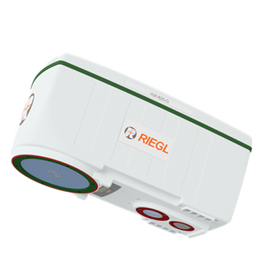
The “All-In” Package for Topo-Bathymetric Surveying
With the RIEGL VUX-820-G, RIEGL offers a new compact, fully integrated complete solution for surveying underwater structures and topography.
RIEGL’s “All-in” Package includes:
- the compact and powerful LiDAR sensor
providing up to 2.2 Secchi depth - the RIEGL RiLOC-F-inside inertial navigation system
- an integrated RGB camera to complement the LiDAR data with imagery
- RIEGL‘s proprietary software licenses for generating georeferenced and refraction-corrected point clouds
The compact design and the light weight of just 5.7 kg / 12.5 lbs make the RIEGL VUX-820-G especially well-suited for use on UAVs. Extra features like a display and status LEDs enhance interactive handling and operation.
Making bathymetric LiDAR more accessible by enabling easy integration and operation:
The VUX-820-G, RIEGL’s perfectly prepared complete solution for topo-bathymetric surveys!
More info: https://www.riegl.com/vux-820-g/
UAV-BASED LASER SCANNING
RIEGL RiLOC-F-inside:

Everything You Need - Seamlessly Integrated in One Compact System
Last year, RIEGL presented its IMU/GNSS solutions RiLOC-E-25 and RiLOC-F at Intergeo, enabling it to offer high-performance LiDAR sensors and matching IMU/GNSS solutions from a single source.
RIEGL now provides a new high-precision, fully integrated subsystem for localization and orientation (Localization/Orientation/Component), the RiLOC-F-inside IMU/GNSS solution for VUX-series laser scanners, that is fully integrated in the VUX-100-25, VUX-120-23, VUX-160-23 and VUX-180-24 UAV LiDAR sensors. It includes a high precision Micro Electro Mechanical System (MEMS) Inertial Measurement Unit (IMU), a GNSS unit, and corresponding software.
Redefining size, weight, and performance standards:
- High-precision positioning: 0.02 – 0.03 m (post-processed)
- No increase in system dimensions
- Minimal additional weight
- Tightly coupled IMU, GNSS, and LiDAR data
- Fully integrated into the RIEGL post-processing workflow
The solution you’ve been looking for.
An all-in-one fully integrated system for small-scale LiDAR surveys with multirotor, fixed-wing, or VTOL drones!
More info: https://www.riegl.com/infosheet_riloc-f/
MOBILE LASER SCANNING
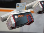
The RIEGL VMX-3HA Mobile Mapping System:
Driving the Future of Mobile LiDAR
RIEGL’s new VMX-3HA Mobile Mapping System sets a new standard for high-speed, high-accuracy mobile LiDAR.
Powered by two RIEGL VUX-3HA laser scanners, it captures the full 360° environment with scanning speeds up to 6 MHz PRR and 800 lines per second – delivering dense, detailed data without slowing down.
What makes the VMX-3HA stand out?
- 360° Precision in Motion
Whether you’re mapping city streets or highways, the VMX-3HA delivers full-environment coverage with pinpoint accuracy – even at high speeds. - Ultra-Dense Data, Near and Far
From fine pavement textures to overhead cables and distant vegetation, every detail is captured with clarity and depth. - Effortless Efficiency
Maintain high point densities at faster platform speeds. The VMX-3HA keeps quality high and workflows smooth, even under demanding conditions.
Built for professionals in transportation, infrastructure, and environmental mapping, the VMX-3HA Mobile Mapping System combines speed, precision, and efficiency in one powerful system – ready to take on complex projects with confidence.
More info: https://www.riegl.com/vmx-3ha/