- project-oriented software for managing and processing RIEGL ALS, ULS and MLS data
- operation in a multiple-workstation environment, parallel task processing
- fast access to data for inspection in different visualization formats
- system calibration and scandata adjustment
- statistical analysis of referencing, matching quality
- point cloud classification
- interfacing to third party software packages
RiPROCESS

RiPROCESS is the RIEGL software package for kinematic LiDAR data processing. It is designed for managing, processing, analyzing, and visualizing data acquired with airborne laser scanning systems (ALS systems), unmanned laser scanning systems (ULS systems), and mobile laser scanning systems (MLS systems) based on RIEGL Laser Scanners.
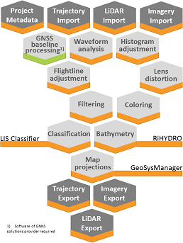
With the native support of any raw LiDAR project collected with the RIEGL software RiACQUIRE, it provides a seamless workflow from field collection to analytics ready point clouds:
System calibration: Based on accurate timestamping, RiPROCESS manages collections and links between trajectories, imagery and point cloud data for the entire project. It stores and applies all relevant system calibration information to handle the different types of data.
Raw data processing: A built-in waveform module provides high accurate echo extraction and analysis from raw waveform LiDAR and creates spatially sorted discrete point clouds. Multiple-Time-Around (MTA) ambiguities - inevitable by use of high speed LiDAR engines are resolved with state of the art technology. Camera calibration information is used to apply lens distortion correction to any imagery collected with the LiDAR data.
Trajectory adjustment: Datasets are organized in records to undergo rigid and non-rigid data registration and georeferencing procedures to match external ground control.
Point cloud processing: Point clouds can be filtered and coloured to meet further analytics requirements.
Data export: Processed point clouds, imagery and trajectory data can be exported to industry standard export formats for easy access in 3rd party software for further analytics or feature extraction. Where supported by the data format, the data can be transformed into EPSG, or user defined target coordinate reference systems or map projections via the included GeoSysManager.
Functionality enhancement: The core functionality of RiPROCESS can be extended by Plug-In software tools. For topo-bathymetric LiDAR data processing, RIEGL offers a RiHYDRO Plug-In to extract water surface models and apply refraction and runtime corrections on subsurface LiDAR measurements. The LIS ALS Classification Plug-In provides additional classification routines for the ASPRS compliant classes ground, building, low/medium/high vegetation.
The new version RiPROCESS 1.9.4, launched in February 2024, provides additional benefits, see here.


